
Dresden floods in 2002.


Dresden lies on the river Elbe and several other waterways originating in the Eastern Ore Mountains, in the German state of Saxony.[1]Due to Dresden’s proximity to these mountains, where heavy rainfall or snowmelt can accumulate, flood protection has been critical historically and today. To mitigate flood risks, urban planners left areas along the Elbe riverbank free of buildings, removed embankments, and created two flood channels. The historic city centre and many historic village centres along the Elbe are on higher ground, offering protection from most floods. However, the Elbe flood of 2002 caused significant damage, heightening public awareness of the city’s vulnerability.[2][3]
Location and river courses
Elbe
Dresden is situated in the Dresden Basin, a wide, flat valley with some narrow sections. Upstream, the Elbe emerges from the Czech Republic through a steep valley in the Elbe Sandstone Mountains, draining tributaries like the Vltava, Orlice, Jizera, and Eger, which collect water from the Krkonoše Mountains, Bohemian Central Mountains, Ore Mountains, Bohemian Forest, and Bavarian Forest. Downstream, the Elbe passes through the Spaargebirge and Meissen vineyards before entering its flat, slow middle course.[1]

The Elbe flows through Dresden in several shallow, narrow meanders, tightening westward. Near the city centre, a 4-km curve bends from northwest to southwest, approaching the northern Elbe slope closely. In the city centre, the Elbe turns northwest, then sharply south at the Pieschener Winkel, before exiting Dresden northwestward after two more bends. The river spans about 30 km within the city.[1]
The Dresden Basin provided ample space for urban development around the Elbe. However, the steep hinterland and lack of space prevented diverting the river around the city centre, unlike the Elbe diversion canal near Magdeburg.[1]
Weißeritz

The Weißeritz (White River) originates in the Eastern Ore Mountains at the confluence of the Wilder Weißeritz and Roter Weißeritz in Freital, 12 km long. Its tributaries, with catchment areas totaling 323.9 km², rise at 823 m and 787 m, about 30 km southeast of Dresden. The Wild Weißeritz, at 49 km, is the longest tributary.[1]

Originally, the Weißeritz flowed into the Elbe near the city centre, separating Friedrichstadt from it. In 1893, it was rerouted westward through Cotta for flood protection, with the former riverbed repurposed for railway facilities, making the relocation permanent.[1]
Flood risk

Dresden faces flood risks from the Elbe and its tributaries, notably the Weißeritz and Lockwitzbach. Smaller Class II tributaries pose localized threats. Flooding causes damage through surface water, rising groundwater, and shifting groundwater locations, with prolonged effects on groundwater levels.[2][1]
Elbe
Flood
The Elbe’s average water level in Dresden, measured at the Augustus Bridge, is 2 m, with a flow rate of about 350 m³/s. Flood alert levels are 4 m (previously 3.5 m until July 2012), 5 m, 6 m, and 7 m.[3]

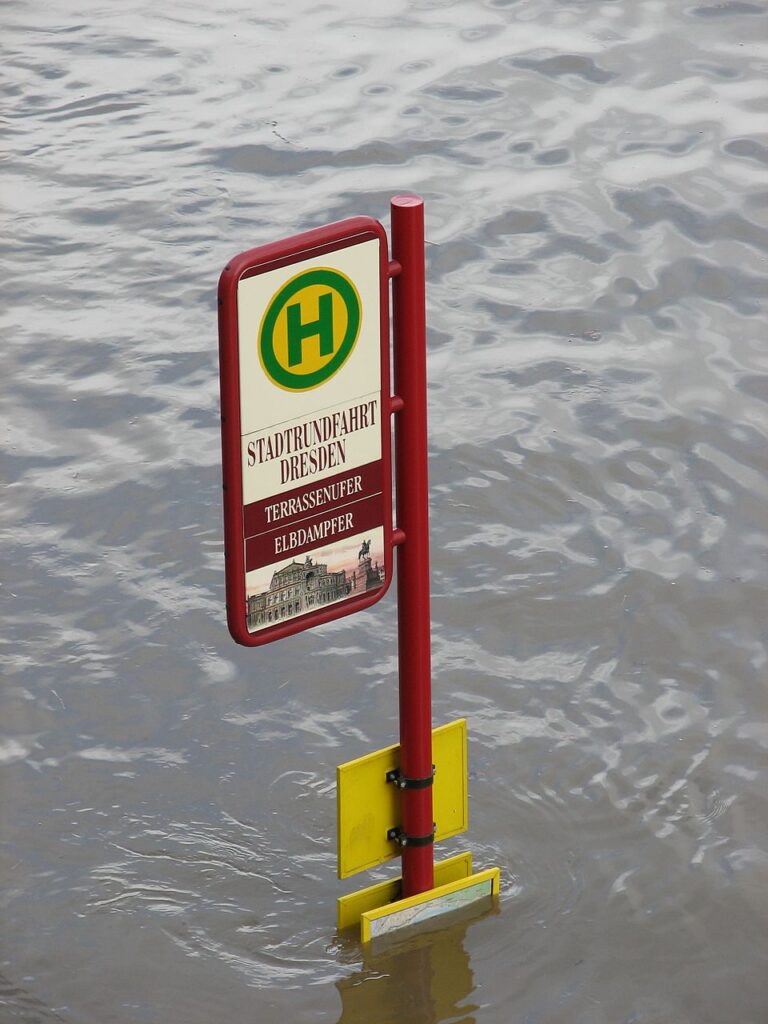
At 4–5 m, flooding is minimal, affecting only riverside roads like Terrassenufer, where the Weiße Flotte boats moor. At 6–7 m, rising groundwater threatens nearby areas, prompting property protection. Above 7 m, low-lying districts like Gohlis (west) and Laubegast and Pillnitz (east) are at risk. The 3.2-km dike from Niederwartha to Stetzsch protects up to 7.4 m, acting as a flood polder beyond this level.[1]

Above 8 m, flooding escalates, filling old Elbe arms and overwhelming flood channels, affecting Laubegast, Kleinzschachwitz, Leuben, Dobritz, and Seidnitz. The 2002 flood reached 9.4 m (4,500 m³/s), flooding 24.8 km² and threatening the Semperoper and Frauenkirche.[2][4]
Frequency and origin
The Elbe, a rain-snow river, is prone to floods from Czech tributaries (e.g., Vltava, Eger) and German sources. Floods of 4–5 m are common during snowmelt, but 7 m floods are rare, with the 2006 spring flood being the first in 52 years to exceed this. The 1845 March flood was the worst winter flood. Intense winters in Czech and German low mountain ranges, followed by late March thaws, drive severe flooding. Summer floods, like 2002 and 2013, result from heavy rainfall under Vb weather conditions, with a 100–200-year recurrence interval for 2002’s severity.[1]
Groundwater
The Dresden Basin‘s clay, sandstone, and pläner layers retain groundwater, with gravel and sand deposits near the Elbe. Groundwater levels track Elbe floods, peaking 2–3 days after flood peaks at Dresden Castle. In 2002, groundwater remained elevated for months, exacerbated by Weißeritz and Lockwitzbach seepage and local rainfall.[2]
Weißeritz
Endangerment
The Weißeritz, with a 2002 peak flow of 450 m³/s, flooded Friedrichstadt, Wilsdruffer Vorstadt, Seevorstadt, and Hauptbahnhof, covering 5.67 km². Its rerouted course through Cotta mitigates city centre flooding, but breaches in Löbtau caused widespread damage.[4]
Frequency and origin

Heavy rainfall or rapid snowmelt in the Osterzgebirge triggers Weißeritz floods, as in 2002 (300 L/m² in 24 hours). Comparable floods occurred in 1897 and 1958, with a 500-year recurrence interval. The riverbed handles 220–420 m³/s, but narrow sections limit capacity to 75 m³/s, leading to frequent overflows (every 20–50 years).[5]
Other bodies of water
The Lockwitzbach flooded Lockwitz, Niedersedlitz, Kleinzschachwitz, Leuben, and Laubegast in 2002 (45 m³/s), covering 2.313 km² via relief ditches. Its riverbed capacity is 25–40 m³/s, with floods every 20–50 years. The Prießnitz threatens Äußere Neustadt. Smaller streams like the Weidigtbach, now with retention basins, reduce localized risks.[6]
Threat to infrastructure

Railway and transport hubs in Seevorstadt, Wilsdruffer Vorstadt, and Friedrichstadt are vulnerable to Weißeritz flooding, collapsing within 24 hours in 2002. Affected areas include Postplatz, Könneritzstraße, and Hauptbahnhof. Pirnaische Platz and Dresden-Neustadt station serve as backup hubs. Hospitals, like Friedrichstadt’s, required evacuation, and underground car parks and the Wiener Platz tunnel flooded. Elbe floods disrupt bridges and road substructures via groundwater.[7]
Threat to residential areas

Approximately 155,000 people live in Elbe-adjacent districts, with population densities ranging from 300 to 8,600 inhabitants/km². Southeastern districts (Zschieren, Kleinzschachwitz, Pillnitz, Wachwitz, Laubegast, Tolkewitz) have village origins on higher ground, largely safe from 2002 floods. Lower areas in Laubegast and Kleinzschachwitz face groundw[6]ater and surface water risks. Blasewitz, Striesen, Johannstadt, and Pirnaische Vorstadt near the city centre are less affected but vulnerable to groundwater. Pieschen, Trachenberge, and Mickten risk severe flooding due to the Pieschener Winkel’s sharp curve. Gohlis’s dike protects up to 7.4 m.[7]


History of flood protection
Flood records date to 1216, when Dresden was first documented. Village centres were built on elevated ground to avoid floods. The 1845 March flood, with ice drift, devastated Dresden, mapping drainage patterns and prompting modern flood protection.[6]
In 1865, the Elbe’s width and banks were defined, and the river was deepened to enhance flow and navigation. Building restrictions preserved the visual connection between Brühl’s Terrace and the Elbe castles, while reducing flood damage. In 1869, the Saxon Ministry of Finance designated development areas, creating Käthe-Kollwitz-Ufer as a flood-free road. During the Gründerzeit, Johannstadt and Blasewitz grew, with the latter’s high-value land driven by Elbe views.[6]
After the 1890 flood, flood channels were built in Ostragehege (1904) and between Mickten and Kaditz (1918–1922), relieving city centre pressure. The Augustus Bridge was renovated in 1904 for better traffic and shipping. Gohlis’s polder system, established early 20th century, protects up to 7.4 m, diverting ice floes during winter floods.[6]
Flood protection
Flood channels
The Elbe meadows, spanning metres to hundreds of metres, protected areas like Striesen and Blasewitz in 2002. Two flood channels straighten meanders during floods: the Ostragehege channel (1904), flowing through the Augustus Bridge at 6.2 m, and the Mickten-Kaditz channel (1918–1922), active at 5.5 m.[8]
Dike systems
Gohlis’s polder system protects up to 7.4 m, with low dikes (e.g., Käthe-Kollwitz-Ufer) preventing erosion. No major dikes exist in eastern districts like Laubegast, where village centres are elevated.[8]
Flood control
The Malter, Klingenberg, and Lehnmühle Dams control Weißeritz floodwaters, while the Kauscha Dam manages the Geberbach. The Hugo-Bürkner-Park retention basin (20,000 m³ post-2006 expansion) protects Strehlen and the Großer Garten.[8]
Expansion in the 21st century
Since 2002, Dresden has implemented steel plank protective walls, protecting the city centre up to 9.24 m. Gohlis’s polder system was enhanced post-2006 with a dike. A proposed Lockwitzbach retention basin and gauge at Lockwitztalbrücke are prioritized. Laubegast’s protective wall was delayed due to resident opposition, leaving it vulnerable in 2013.[8]

