
{{Use mdy dates|date=July 2023}}
{{Use mdy dates|date=July 2023}}
{{Infobox settlement
{{Infobox settlement
|official_name = Loyal, Wisconsin
|official_name = Loyal, Wisconsin
|settlement_type = [[City]]
|settlement_type = [[City]]
|nickname =
|nickname =
|motto =
|motto
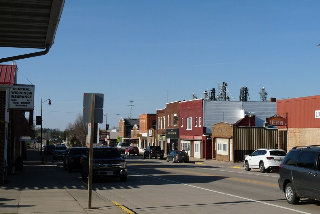
| image_skyline = Loyal Wisconsin Main Street.jpg
| imagesize =
| image_caption = The old downtown, looking north on [[Wisconsin Highway 98|WIS 98]]
| image_flag =
| image_seal = <!– Maps –>
| image_map = File:Clark County Wisconsin Incorporated and Unincorporated areas Loyal Highlighted.svg
| mapsize =
| map_caption = Location of Loyal in Clark County, Wisconsin.
| pushpin_map = Wisconsin#USA
| pushpin_label = Loyal
| pushpin_relief = yes
<!– Location –>| subdivision_type = [[List of sovereign states|Country]]
<!– Images –>
| subdivision_name = {{flag|United States}}
|image_skyline = Loyal Wisconsin Main Street.jpg
| subdivision_type1 = [[U.S. state|State]]
|imagesize =
| subdivision_name1 = {{flag|Wisconsin}}
|image_caption = The old downtown, looking north on [[Wisconsin Highway 98|WIS 98]]
| subdivision_type2 = [[List of counties in Wisconsin|County]]
|image_flag =
| subdivision_name2 = [[Clark County, Wisconsin|Clark]]
|image_seal =
<!– Maps –>
<!– –>
| government_type =
|image_map = File:Clark County Wisconsin Incorporated and Unincorporated areas Loyal Highlighted.svg
|mapsize =
| =
| leader_name =
|map_caption = Location of Loyal in Clark County, Wisconsin.
| leader_title1 =
|pushpin_map = Wisconsin#USA
|pushpin_label = Loyal
| =
| established_title =
|pushpin_relief = yes
| established_date = <!– Area –>
| unit_pref = Imperial
| area_footnotes = <ref name=”CenPopGazetteer2019″>{{cite web|title=2019 U.S. Gazetteer Files|url=https://www2.census.gov/geo/docs/maps-data/data/gazetteer/2019_Gazetteer/2019_gaz_place_55.txt|publisher=United States Census Bureau|access-date=August 7, 2020}}</ref>
| area_magnitude =
| area_total_km2 = 3.54
| area_land_km2 = 3.54
| area_water_km2 = 0.00
| area_total_sq_mi = 1.37
| area_land_sq_mi = 1.37
| area_water_sq_mi = 0.00
<!– Population –>| population_as_of = [[2020 United States census|2020]]
<!– Location –>
| population_footnotes =
|subdivision_type = [[List of sovereign states|Country]]
| population_total = 1203
|subdivision_name = {{flag|United States}}
| population_density_km2 = auto
|subdivision_type1 = [[U.S. state|State]]
| population_density_sq_mi = auto
|subdivision_name1 = {{flag|Wisconsin}}
|subdivision_type2 = [[List of counties in Wisconsin|County]]
|subdivision_name2 = [[Clark County, Wisconsin|Clark]]
<!– General information –>| timezone = [[North American Central Time Zone|Central (CST)]]
<!– Government –>
|government_footnotes =
| =
|government_type =
| =
|leader_title =
| =
| elevation_footnotes = <ref name=”GR3″>{{cite web|url=http://geonames.usgs.gov|access-date=2008-01-31|title=US Board on Geographic Names|publisher=[[United States Geological Survey]]|date=2007-10-25}}</ref>
|leader_name =
|leader_title1 =
| =
|leader_name1 =
| =
| coordinates = {{coord|44|44|15|N|90|29|48|W|region:US_type:city|display=inline,title}}
|established_title =
| postal_code_type = [[ZIP code]]
|established_date =
| postal_code = 54446
| area_codes = [[Area codes 715 and 534|715 & 534]]
<!– Area –>
| blank_name = [[Federal Information Processing Standard|FIPS code]]
|unit_pref = Imperial
|area_footnotes = <ref name=”CenPopGazetteer2019“>{{cite web|title=2019 U.S. Gazetteer Files|url=https://www2.census.gov/geo/docs/maps-data/data/gazetteer/2019_Gazetteer/2019_gaz_place_55.txt|publisher=United States Census Bureau|access-date=August 7, 2020}}</ref>
| = <ref name=””>{{cite web|url=https://.census.gov|publisher=United States Census Bureau|access-date= }}</ref>
| blank1_name = [[Geographic Names Information System|GNIS]] feature ID
|area_magnitude =
|area_total_km2 = 3.54
| =
|area_land_km2 = 3.54
| = .
|area_water_km2 = 0.00
| =
|area_total_sq_mi = 1.37
|area_land_sq_mi = 1.37
|area_water_sq_mi = 0.00
<!– Population –>
|population_as_of = [[2010 United States Census|2010]]
|population_est = 1233
|pop_est_as_of = 2019
|population_footnotes = <ref name =”wwwcensusgov”/>
|population_total = 1261
|population_density_km2 = 347.89
|population_density_sq_mi = 901.32
<!– General information –>
|timezone = [[North American Central Time Zone|Central (CST)]]
|utc_offset = -6
|timezone_DST = CDT
|utc_offset_DST = -5
|elevation_footnotes = <ref name=”GR3″>{{cite web|url=http://geonames.usgs.gov|access-date=2008-01-31|title=US Board on Geographic Names|publisher=[[United States Geological Survey]]|date=2007-10-25}}</ref>
|elevation_m = 378
|elevation_ft = 1240
|coordinates = {{coord|44|44|15|N|90|29|48|W|region:US_type:city|display=inline,title}}
|postal_code_type = [[ZIP code]]
|postal_code = 54446
|area_codes = [[Area codes 715 and 534|715 & 534]]
|blank_name = [[Federal Information Processing Standard|FIPS code]]
|blank_info = 55-46075<ref name=”GR2″>{{cite web|url=https://www.census.gov|publisher=[[United States Census Bureau]]|access-date=2008-01-31|title=U.S. Census website}}</ref>
|blank1_name = [[Geographic Names Information System|GNIS]] feature ID
|blank1_info = 1568773<ref name=”GR3″ />
|website = {{URL|loyalwi.com}}
|footnotes =
|pop_est_footnotes = <ref name=”USCensusEst2019CenPopScriptOnlyDirtyFixDoNotUse”/>
}}
}}
”’Loyal”’ is a city in [[Clark County, Wisconsin]], United States. The population was 1,261 at the [[2010 United States Census|2010 census]]. The city is located within the [[Loyal, Clark County, Wisconsin|Town of Loyal]], though it is politically independent.
”’Loyal”’ is a city in [[Clark County, Wisconsin]], United States. The population was 1, at the [[ United States | census]]. The city is located within the [[Loyal, Clark County, Wisconsin|Town of Loyal]], though it is politically independent.
Its name comes from the 1860s, when so many of its patriotic pioneers went to fight in the Civil War.<ref>{{cite book|last1=Moyer|first1=Armond|last2=Moyer|first2=Winifred|title=The origins of unusual place-names|url=https://babel.hathitrust.org/cgi/pt?id=wu.89058322223;view=1up;seq=85|year=1958|publisher=Keystone Pub. Associates|page=81}}</ref> A store was established at the site in 1870, the place platted in 1885, incorporated as a village in 1893,<ref>{{cite web| url= http://www.usgennet.org/usa/wi/county/clark/clark/history/1915ClarkCoHistory/1_Loyal.htm|title=The Village of Loyal|publisher= usgennet.org|access-date=December 27, 2019}}</ref> and changed to a city in 1948.
Its name comes from the 1860s, when so many of its patriotic pioneers went to fight in the Civil War.<ref>{{cite book|last1=Moyer|first1=Armond|last2=Moyer|first2=Winifred|title=The origins of unusual place-names|url=https://babel.hathitrust.org/cgi/pt?id=wu.89058322223;view=1up;seq=85|year=1958|publisher=Keystone Pub. Associates|page=81}}</ref> A store was established at the site in 1870, the place platted in 1885, incorporated as a village in 1893,<ref>{{cite web| url= http://www.usgennet.org/usa/wi/county/clark/clark/history/1915ClarkCoHistory/1_Loyal.htm|title=The Village of Loyal|publisher= usgennet.org|access-date=December 27, 2019}}</ref> and changed to a city in 1948.
==Demographics==
==Demographics==
{{US Census population
{{US Census population
|1880= 46
|1880= 46
|1900= 645
|1900= 645
|1910= 677
|1910= 677
|1920= 735
|1920= 735
|1930= 862
|1930= 862
|1940= 921
|1940= 921
|1950= 1104
|1950= 1104
|1960= 1146
|1960= 1146
|1970= 1126
|1970= 1126
|1980= 1252
|1980= 1252
|1990= 1244
|1990= 1244
|2000= 1308
|2000= 1308
|2010= 1261
|2010= 1261
| 2020 = 1203
|estyear=2019
| footnote = U.S. Decennial Census<ref name=”DecennialCensus”>{{cite web|url=https://www.census.gov/programs-surveys/decennial-census.html|title=Census of Population and Housing|publisher=Census.gov|access-date=June 4, 2015}}</ref>
|estimate=1233
|estref=<ref name=”USCensusEst2019CenPopScriptOnlyDirtyFixDoNotUse”>{{cite web|url=https://www.census.gov/programs-surveys/popest/data/tables.2019.html|date=May 24, 2020|title=Population and Housing Unit Estimates|publisher=United States Census Bureau|access-date=May 27, 2020}}</ref>
|footnote=U.S. Decennial Census<ref name=”DecennialCensus”>{{cite web|url=https://www.census.gov/programs-surveys/decennial-census.html|title=Census of Population and Housing|publisher=Census.gov|access-date=June 4, 2015}}</ref>
}}
}}
City in Wisconsin, United States
Loyal is a city in Clark County, Wisconsin, United States. The population was 1,203 at the 2020 census.[4] The city is located within the Town of Loyal, though it is politically independent.
Its name comes from the 1860s, when so many of its patriotic pioneers went to fight in the Civil War.[5] A store was established at the site in 1870, the place platted in 1885, incorporated as a village in 1893,[6] and changed to a city in 1948.

Loyal is located at 44°44′15″N 90°29′47″W / 44.73750°N 90.49639°W (44.737541, -90.496551).[7]
According to the United States Census Bureau, the city has a total area of 1.39 square miles (3.60 km2), all of it land.[8]

As of the census[10] of 2010, there were 1,261 people, 538 households, and 344 families living in the city. The population density was 907.2 inhabitants per square mile (350.3/km2). There were 603 housing units at an average density of 433.8 per square mile (167.5/km2). The racial makeup of the city was 98.3% White, 0.2% African American, 0.5% Native American, 0.2% Asian, 0.6% from other races, and 0.2% from two or more races. Hispanic or Latino of any race were 1.0% of the population.
There were 538 households, of which 29.6% had children under the age of 18 living with them, 49.6% were married couples living together, 10.2% had a female householder with no husband present, 4.1% had a male householder with no wife present, and 36.1% were non-families. 29.7% of all households were made up of individuals, and 14.1% had someone living alone who was 65 years of age or older. The average household size was 2.34 and the average family size was 2.88.
The median age in the city was 41 years. 24.8% of residents were under the age of 18; 7.7% were between the ages of 18 and 24; 24.5% were from 25 to 44; 20.3% were from 45 to 64; and 22.8% were 65 years of age or older. The gender makeup of the city was 49.1% male and 50.9% female.
As of the census[3] of 2000, there were 1,308 people, 548 households, and 366 families living in the city. The population density was 951.8 people per square mile (368.6/km2). There were 576 housing units at an average density of 419.1 per square mile (162.3/km2). The racial makeup of the city was 98.93% White, 0.46% Black or African American, 0.08% Asian, 0.23% from other races, and 0.31% from two or more races. 0.76% of the population were Hispanic or Latino of any race.
There were 548 households, out of which 28.8% had children under the age of 18 living with them, 54.0% were married couples living together, 9.1% had a female householder with no husband present, and 33.2% were non-families. 29.7% of all households were made up of individuals, and 16.6% had someone living alone who was 65 years of age or older. The average household size was 2.38 and the average family size was 2.94.
In the city, the population was spread out, with 26.0% under the age of 18, 6.7% from 18 to 24, 27.1% from 25 to 44, 19.0% from 45 to 64, and 21.3% who were 65 years of age or older. The median age was 37 years. For every 100 females, there were 89.8 males. For every 100 females age 18 and over, there were 86.2 males.
The median income for a household in the city was $30,647, and the median income for a family was $38,026. Males had a median income of $27,727 versus $20,197 for females. The per capita income for the city was $16,502. About 5.4% of families and 10.5% of the population were below the poverty line, including 14.0% of those under age 18 and 13.5% of those age 65 or over.
Loyal has three schools: Loyal Elementary School; Loyal High School, home of the Greyhounds; and Saint Anthony’s Catholic School.
Loyal’s biggest event is the Loyal Corn Festival.
-

The old downtown, looking north
-

The sign for Loyal on WIS 98
-

Loyal Historical Society buildings
-

United Methodist Church


- ^ “2019 U.S. Gazetteer Files”. United States Census Bureau. Retrieved August 7, 2020.
- ^ a b “US Board on Geographic Names”. United States Geological Survey. October 25, 2007. Retrieved January 31, 2008.
- ^ a b “U.S. Census website”. United States Census Bureau. Retrieved January 31, 2008.
- ^ “Census Bureau profile: Loyal city, Wisconsin”. United States Census Bureau. May 2023. Retrieved November 23, 2025.
- ^ Moyer, Armond; Moyer, Winifred (1958). The origins of unusual place-names. Keystone Pub. Associates. p. 81.
- ^ “The Village of Loyal”. usgennet.org. Retrieved December 27, 2019.
- ^ “US Gazetteer files: 2010, 2000, and 1990”. United States Census Bureau. February 12, 2011. Retrieved April 23, 2011.
- ^ “US Gazetteer files 2010”. United States Census Bureau. Archived from the original on July 2, 2012. Retrieved November 18, 2012.
- ^ “Census of Population and Housing”. Census.gov. Retrieved June 4, 2015.
- ^ “U.S. Census website”. United States Census Bureau. Retrieved November 18, 2012.
- ^ ‘Wisconsin Blue Book 1911,’ Biographical Sketch of Fred W. Draper, pg. 754
- ^ ‘Wisconsin Blue Book 1893,’ Biographical Sketch of Baldwin W. Fullmer, pg. 637
- ^ Wisconsin Senate-Mary Lazich

