
== History ==
== History ==
[[File:Dom przy ul. Kokosowej 30 w Warszawie 2020.jpg|thumb|220px|left|A wooden house at 30 Kokosowa Street pictured in 2020, one of the remaining historical structures in Wolica.]]
[[File:Dom przy Kokosowej w Warszawie .jpg|thumb|220px|left|A wooden house at Kokosowa Street , the in Wolica.]]
Wolica, historically known as ”Wola Służewska” ({{IPA|pl|ˈvɔ.la swuˈʐɛf.ska}}) was founded in the second half of the 14th century.<ref name=piber203>Marta Piber: ”Służew średniowieczny”. Warsaw: Towarzystwo Naukowe Warszawskie, 2001, p. 203. ISBN 83-907328-5-8. (in Polish)</ref><ref name=ew757>Barbara Petrozolin-Skowrońska (editor): Encyklopedia Warszawy, vol 1. Warsaw: Wydawnictwo Naukowe PWN, 1994, p. 757. ISBN 9788301088361. (in Polish)</ref> The first known records of it come from 1424.<ref name=wolff>Adam Wolff, Kazimierz Pacuski: ”Słownik historyczno-geograficzny Ziemi Warszawskiej w średniowieczu”. Warsaw: Instytut Historii PAN, 2013, p. 323. ISBN 978-83-63352-17-2. (in Polish)</ref> The names ”Wolica” and ”Wola” are related to [[Polish language|Polish]] term ”wolność” (“freedom”). Historically, since 13th century, name ”Wola” was given to the villages whose population had certain freedoms, such as being exempt from paying taxes.<ref name=handke>Kwiryna Handke: ”Dzieje Warszawy nazwami pisane”. Warsaw: Warsaw History Museum, 2011, p. 296, 322. ISBN 978-83-62189-08-3. (in Polish)</ref> This suggests that Wolica was founded as one of such settlements, attracting settlers with a temporary exemption of taxation.<ref>Józef Kazimierski, Ryszard Kołodziejczyk, Żanna Kormanowa, Halina Rostowska: ”Dzieje Mokotowa”. Warsaw: Państwowe Wydawnictwo Naukowe, 1972, p. 26. (in Polish)</ref> The village was part of the [[Catholic Church|Catholic]] parish of the [[Church of St. Catherine (Warsaw)|Church of St. Catherine]].<ref name=piber203/> Wolica was located at the road between [[Warsaw]] and [[Czersk, Masovian Voivodeship|Czersk]], which currently forms part of Nowoursynowska Street. In 1528, together with its farmlands, it had a total area of around 85 ha, and was owned by the Wierzbów family.<ref>Adolf Pawiński: ”Polska XVI wieku pod względem geograficzno-statystycznym”, vol. 5: ”Mazowsze”. Warsaw, 1895, p. 261. (in Polish)</ref>
Wolica, historically known as ”Wola Służewska” ({{IPA|pl|ˈvɔ.la swuˈʐɛf.ska}}) was founded in the second half of the 14th century.<ref name=piber203>Marta Piber: ”Służew średniowieczny”. Warsaw: Towarzystwo Naukowe Warszawskie, 2001, p. 203. ISBN 83-907328-5-8. (in Polish)</ref><ref name=ew757>Barbara Petrozolin-Skowrońska (editor): Encyklopedia Warszawy, vol 1. Warsaw: Wydawnictwo Naukowe PWN, 1994, p. 757. ISBN 9788301088361. (in Polish)</ref> The first known records of it come from 1424.<ref name=wolff>Adam Wolff, Kazimierz Pacuski: ”Słownik historyczno-geograficzny Ziemi Warszawskiej w średniowieczu”. Warsaw: Instytut Historii PAN, 2013, p. 323. ISBN 978-83-63352-17-2. (in Polish)</ref> The names ”Wolica” and ”Wola” are related to [[Polish language|Polish]] term ”wolność” (“freedom”). Historically, since 13th century, name ”Wola” was given to the villages whose population had certain freedoms, such as being exempt from paying taxes.<ref name=handke>Kwiryna Handke: ”Dzieje Warszawy nazwami pisane”. Warsaw: Warsaw History Museum, 2011, p. 296, 322. ISBN 978-83-62189-08-3. (in Polish)</ref> This suggests that Wolica was founded as one of such settlements, attracting settlers with a temporary exemption of taxation.<ref>Józef Kazimierski, Ryszard Kołodziejczyk, Żanna Kormanowa, Halina Rostowska: ”Dzieje Mokotowa”. Warsaw: Państwowe Wydawnictwo Naukowe, 1972, p. 26. (in Polish)</ref> The village was part of the [[Catholic Church|Catholic]] parish of the [[Church of St. Catherine (Warsaw)|Church of St. Catherine]].<ref name=piber203/> Wolica was located at the road between [[Warsaw]] and [[Czersk, Masovian Voivodeship|Czersk]], which currently forms part of Nowoursynowska Street. In 1528, together with its farmlands, it had a total area of around 85 ha, and was owned by the Wierzbów family.<ref>Adolf Pawiński: ”Polska XVI wieku pod względem geograficzno-statystycznym”, vol. 5: ”Mazowsze”. Warsaw, 1895, p. 261. (in Polish)</ref>
Neighbourhood in Warsaw, Poland
Neighbourhood in Warsaw, Masovian Voivodeship, Poland
Wolica (Polish pronunciation: [vɔˈli.t͡sa]) is a neighbourhood in the city of Warsaw. It is located at the boundary between districts of Ursynów and Wilanów, and divided between City Information System areas of Ursynów-Centrum and Błonia Wilanowskie. It is a small residential area consisting of single-family housing, centred in the area Kokosowa Street.
Wolica was most likely founded in the 14th century, and its oldest known records date to 1424.[1][2] Throughout most of its history, it was a small farming community.[3] In 1951, it was incorporated into Warsaw. In the 1970s and 1980s, most of its area became part of then-constructed multifamily housing neighbourhood of Na Skraju.[4][5]
History

Wolica, historically known as Wola Służewska (Polish pronunciation: [ˈvɔ.la swuˈʐɛf.ska]) was founded in the second half of the 14th century.[1][6] The first known records of it come from 1424.[2] The names Wolica and Wola are related to Polish term wolność (“freedom”). Historically, since 13th century, name Wola was given to the villages whose population had certain freedoms, such as being exempt from paying taxes.[7] This suggests that Wolica was founded as one of such settlements, attracting settlers with a temporary exemption of taxation.[8] The village was part of the Catholic parish of the Church of St. Catherine.[1] Wolica was located at the road between Warsaw and Czersk, which currently forms part of Nowoursynowska Street. In 1528, together with its farmlands, it had a total area of around 85 ha, and was owned by the Wierzbów family.[9]
In 1730, the village was bought by a nobleperson and landowner Maria Zofia Czartoryska, and incorporated into the Wilanów Estate.[7] In 1775, Wolica had 15 houses, and in 1827, it had 177 inhabitants in 13 households. Following the abolition of serfdom in 1864, the village was incorporated into the municipality of Wilanów. Additionally, 30 peasant-owned farms were founded there, collectively having an area of 178 ha.[3]
In 1905, Wolica was inhabited by 478 people in 34 houses, all of which were constructed out of wood and with thatched roofs. In 1908, the village burned down, with only two houses surviving. Buildings constructed after the fire were primarily made from brick. In 1912, it had 471 residents, and it included 360 ha of farmland, half of which was owned by local families, and the rest by the noble family of Branicki. Vegetables such as onion and radish were grown there. In 1921, the village was inhabited by 336 people in 40 houses.[3]
During the occupation of Poland in the Second World War, German soldiers were stationed in Wolica.[10]
In 1948, a bus line no. 104, connecting Wolica with the Southern Bus Station in Mokotów was opened.[4][11][12] It ended with a turning loop at Nowoursynowska Street.[12] In 1949, the village was connected to the electric network.[4] Wolica was incorporated into the city of Warsaw on 14 May 1951.[13] In 1956, a portion of its farmlands became property of the Warsaw University of Life Sciences, which organised there a test field for its experiments.[14] In the 1950s, Kolejarz Wolica association football club was also founded in the village.[4] In the 1960s, the construction of new housing buildings in the village was forbidden.[4]
In the 1960s, the construction of new housing buildings in the village was forbidden. Wolica became part of an area where, between 1976 and 1981, the housing estate of Na Skraju was constructed, consisting of high-rise apartment buildings. The land was acquired by the government with small compensation to the residents.[4][5] In 1990, the bus line no. 104 was rerouted away from Wolica, via Rosoła Street to Kabaty, end eventually discontinued in 1993.[12] Since the 1990s, new villas and terraced multi-family houses have been built among the old residential and farm buildings of Wolica.
In 2001, the Blessed Edmund Bojanowski Church, which belongs to the Catholic, began being constructed at 12 Kokosowa Street. Its location in the past featured the Wolica Cemetery, though when it was built and demolished remains unknown.[15][16]
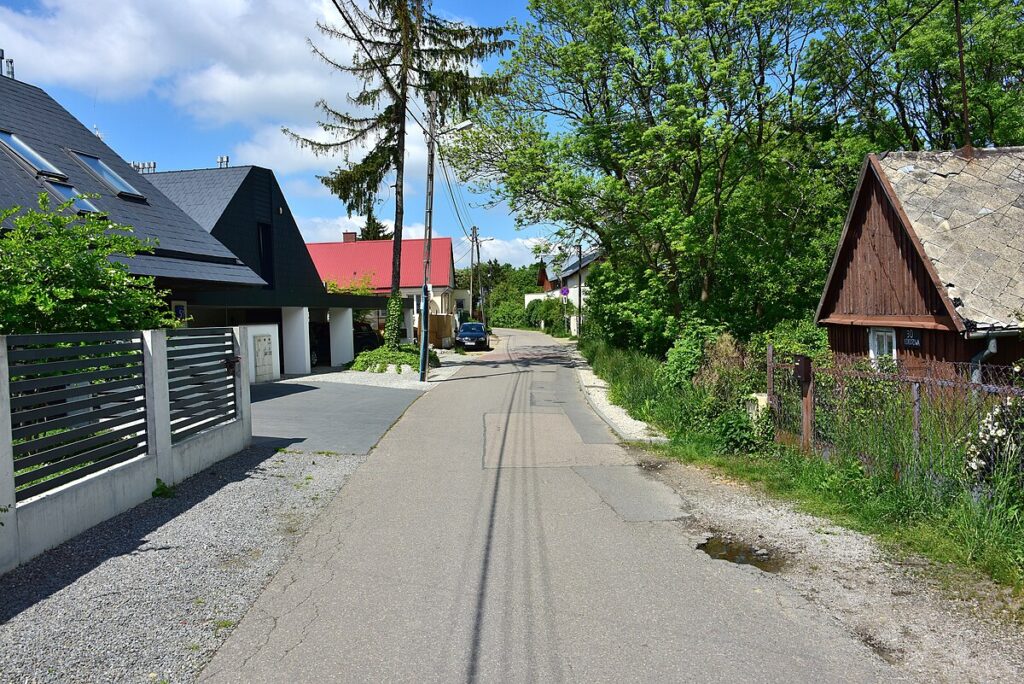
Currently, a few houses of the original Wolica remain, mostly at Kokosowa Street.[12] The oldest of them, located at 27 and 29 Kokosowa Street, dates to 1897, and is listed on the municipal heritage list.[17][18]
Characteristics
Wolica is a small residential neighbourhood with low-rise single-family housing, centred in the area of Kokosowa Street.[12] The neighbourhood is located at the boundary between city districts of Ursynów and Wilanów, and divided between City Information System areas of Ursynów-Centrum and Błonia Wilanowskie.[19][20] The Blessed Edmund Bojanowski Church, which belongs to the Catholic denomination, is currently being constructed at 12 Kokosowa Street.[15][16]
References
- ^ a b c Marta Piber: Służew średniowieczny. Warsaw: Towarzystwo Naukowe Warszawskie, 2001, p. 203. ISBN 83-907328-5-8. (in Polish)
- ^ a b Adam Wolff, Kazimierz Pacuski: Słownik historyczno-geograficzny Ziemi Warszawskiej w średniowieczu. Warsaw: Instytut Historii PAN, 2013, p. 323. ISBN 978-83-63352-17-2. (in Polish)
- ^ a b c Jacek Krawczyk: Ursynów wczoraj i dziś. Warsaw: Wydawnictwo Pagina, 2001, p. 37–40. ISBN 83-86351-37-3. (in Polish)
- ^ a b c d e f Jacek Krawczyk: Ursynów wczoraj i dziś. Warsaw: Wydawnictwo Pagina, 2001, p. 101–109. ISBN 83-86351-37-3. (in Polish)
- ^ a b Barbara Petrozolin-Skowrońska (editor): Encyklopedia Warszawy, vol 1. Warsaw: Wydawnictwo Naukowe PWN, 1994, p. 920–921. ISBN 9788301088361. (in Polish)
- ^ Barbara Petrozolin-Skowrońska (editor): Encyklopedia Warszawy, vol 1. Warsaw: Wydawnictwo Naukowe PWN, 1994, p. 757. ISBN 9788301088361. (in Polish)
- ^ a b Kwiryna Handke: Dzieje Warszawy nazwami pisane. Warsaw: Warsaw History Museum, 2011, p. 296, 322. ISBN 978-83-62189-08-3. (in Polish)
- ^ Józef Kazimierski, Ryszard Kołodziejczyk, Żanna Kormanowa, Halina Rostowska: Dzieje Mokotowa. Warsaw: Państwowe Wydawnictwo Naukowe, 1972, p. 26. (in Polish)
- ^ Adolf Pawiński: Polska XVI wieku pod względem geograficzno-statystycznym, vol. 5: Mazowsze. Warsaw, 1895, p. 261. (in Polish)
- ^ Jacek Krawczyk: Ursynów wczoraj i dziś. Warsaw: Wydawnictwo Pagina, 2001, p. 69. ISBN 83-86351-37-3. (in Polish)
- ^ “104 linia autobusowa zwykła”. trasbus.com (in Polish).
- ^ a b c d e Maciej Mazur: Czterdziestolatek. Historie z Ursynowa. Warsaw: Wydawnictwo Myśliński, 2017, p. 137–139. ISBN 978-83-934764-8-0. (in Polish)
- ^ “Rozporządzenie Rady Ministrów z dnia 5 maja 1951 r. w sprawie zmiany granic miasta stołecznego Warszawy”. isap.sejm.gov.pl (in Polish).
- ^ “Historia”. wobiak.sggw.pl (in Polish). Archived from the original on 2017-03-08. Retrieved 2024-03-08.
- ^ a b Grzegorz Kalwarczyk: Przewodnik po parafiach i kościołach Archidiecezji Warszawskiej, vol. 2: Parafie warszawskie. Warsaw: Oficyna Wydawniczo-Poligraficzna Adam, 2015, p. 258. ISBN 978-83-7821-118-1. (in Polish)
- ^ a b “Warszawa. Bł. Edmunda Bojanowskiego”. archwwa.pl (in Polish).
- ^ Wojciech Karpieszzuk: “Tajemnicza wieś obok Miasteczka Wilanów”, Gazeta Stołeczna, p. 9. Warsaw, 22 August 2025. (in Polish)
- ^ Jerzy Szałygin; Sławomira Kujawa-Mędrzycka (2007). “Karta ewidencyjna zabytków architektury i budownictwa. Dom przy Kokosowej 27/29”. zabytek.pl (in Polish).
- ^ “Obszary MSI. Dzielnica Ursynów”. zdm.waw.pl (in Polish).
- ^ “Obszary MSI. Dzielnica Wilanów”. zdm.waw.pl (in Polish).

