
==Images==
==Images==
A collection of photographs, sketches, and paintings of the Cross from various angles previously provided by canmore.org.uk, now supplemented by RCAHMS and Ordnance Survey records, has been transferred to a more generalised site, hosted by Historic Environment Scotland.<ref name=Trove_Scot–Crosshall_Cross>{{cite web |access-date=2025-12-05 | author= |date=2025 |title=Crosshall |url=https://www.trove.scot/search?q=crosshall%2Bcross&page_type=All&viewmode=list |website=Trove Scot – The Key to Scotland’s Past}}</ref>
A collection of photographs, sketches, and paintings of the Cross from various angles previously provided by canmore.org.uk, now supplemented by RCAHMS and Ordnance Survey records, has been transferred to a more generalised site, hosted by Historic Environment Scotland.
<ref name=Trove_Scot–>{{cite web |access-date=2025-12- | author= |date=2025 |title=Crosshall |url=https://www.trove.scot/ |website=Trove Scot – The Key to Scotland’s Past}}</ref>
<ref name=Trove_Scot–Crosshall_Cross>{{cite web |access-date=2025-12-05 | author= |date=2025 |title=Crosshall (Cross) |url=https://www.trove.scot/search?q=crosshall%2Bcross&page_type=All&viewmode=list |website=Trove Scot – The Key to Scotland’s Past}}</ref>
==Adjacent Cottages==
==Adjacent Cottages==

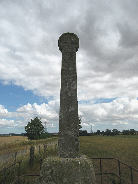
The Crosshall Cross[1] is a wheel-head cross at Crosshall Farm, Eccles, in the Scottish Borders area of Scotland, in the historic county of Berwickshire. Exact coordinates: 55°40′22″N 2°22′54″E / 55.672705°N 2.381559°E.
The cross is situated in a field close to a road about 350 metres south-west of Crosshall farmhouse[2] and is said to date from the 12th century, after the Second Crusade, 1147-49 CE. It is 452 centimetres (14 ft 10 inches)[3] in height and is thought to commemorate someone who had been to the Holy Land. According to local lore a governor of the nearby Hume Castle was killed in a skirmish (R.D. Thomson 1845, page 56). The coat of arms engraved on two sides of the column shaft may be that of the Soulis family.[4]
The cross shaft is set in a sturdy stone socket which, in turn, is set atop a base of masonry. On all sides the shaft tapers slightly up to the head. The aptly named wheel-head, an originally Celtic design[5], is 56 centimetres (1ft 10 inches) in diameter.
The two faces of the cylindrical wheel-head are oriented east-west and each displays the same simple cross relief set within an outer rim.

The four flanks of the cross shaft are engraved with the following figures.
[6]
[4]
[7]
- North flank (N): a latin cross placed on a calvary
- East flank (E): a male figure above a hound positioned upright
- West flank (W): a shield above a latin cross
- South flank (S): a shield above an upright longsword
The two heraldic shields – note above reference to the Soulis family – both depict three chevrons, two side by side at the top of the shield, one centered below, all three pointed upwards. The external link Soulis Surname History & Family Crest links to an image of a triple upright chevron and thus gives reasonable credit to the above assumption.
No engravings are reported on the socket.
Historical Descriptions
[edit]
Descriptions of this monument differ greatly as to which images are recognisable on the various faces of this structure, but some authors report a host of details. A selection of reports:
_Cross%27.jpg)
- The 1854 edition of “The Imperial gazetteer of Scotland; or, Dictionary of Scottish topography”, Section “Berwickshire”, page 164, line 10 states: “… In the parish of Eccles, at Crosshall, there is an upright stone column, with various sculptures; but there is no inscription, nor is there any tradition concerning it.”[9]
- James Hardy (1882-84) described the cross in the late nineteenth century as: “One of the best preserved of the ancient historical monuments of the Merse district”.[2]
- In 2006, the cross was described as such: “a male figure and a hound on one face and a Latin cross on the other; one of the sides has a cross and the other a sword. Shields with unidentified arms are carved on one face and one side, just below the cross-head.”[2]
Ordnance Survey Records
[edit]
The original Ordnance Survey Records for this historical monument, location Crosshall, Eccles Cross, NT74SE 5, are preserved on the following index cards.
A collection of photographs, sketches, and paintings of the Cross from various angles previously provided by canmore.org.uk, now supplemented by RCAHMS and Ordnance Survey records, has been transferred to a more generalised site, hosted by Historic Environment Scotland.
[10]
[11]
On the opposite (northern) side of the road that passes the cross once stood a row of houses, now demolished (2024).
An older painting (ca. 1850)[12] from the above stated collection depicts two entrances to adjacent, presumably thatched roof houses.[13]
Two photographs of the cross taken during the following century, approx. 1960, from a position in the field behind the cross display the then-existant row of 5 slate-roofed houses.[14][15]
Other places nearby include Fogo, Gavinton, the Greenknowe Tower, Greenlaw, Hume Castle, Leitholm, Longformacus, Polwarth, Westruther.
- ^ James Hardy (1855). “On the ancient cross at Crosshall, in the parish of Eccles, Berwickshire”. History of the Berwickshire Naturalists’ Club (Berwickshire Natur Club 10). Retrieved 21 December 2024.
- ^ a b c “Crosshall”. The Berwickshire Place-Name Resource, University of Glasgow. 2006. Retrieved 21 December 2024.
- ^ “Index card for the Crosshall, Eccles Cross, NT74SE 5”. canmore.org.uk. 1983. Retrieved 21 December 2024.
- ^ a b “Crosshall, Eccles Cross, NT74SE 5, Ordnance Survey index card, page number 1, Recto”. www.trove.scot. 1954. Retrieved 6 December 2025.
- ^ “wheel-head cross”. encyclopedia.com. Retrieved 6 December 2025.
- ^ a b “Crosshall, Eccles Cross, NT74SE 5, Ordnance Survey index card, Recto”. www.trove.scot. 1954. Retrieved 6 December 2025.
- ^ “Three sketches of Eccles Market Cross at Crosshall”. www.trove.scot. Retrieved 10 December 2025.
- ^ Andrew Armstrong (1771). “Armstrong, Andrew, 1700-1794; Map of the County of Berwick, South East section, Date: 1771, Excerpt ‘Eccles’“. www.nls.uk. Retrieved 13 December 2025.
- ^ “The Imperial gazetteer of Scotland; or, Dictionary of Scottish topography”. Imperial Gazetteer of Scotland. Edinburgh: A. Fullarton: 164. 1854. Retrieved 21 December 2024.
- ^ “Historical images of the Crosshall or Eccles Cross”. Trove Scot – The Key to Scotland’s Past. 2025. Retrieved 14 December 2025.
- ^ “Crosshall (Cross)”. Trove Scot – The Key to Scotland’s Past. 2025. Retrieved 5 December 2025.
- ^ “Painting of Eccles Market Cross at Crosshall”. Trove Scot – The Key to Scotland’s Past. 1850. Retrieved 6 December 2025.
- ^ J Drummond. “Drawing of Eccles Market Cross at Crosshall”. canmore.org.uk. Retrieved 21 December 2024.
- ^ “South face showing a carved sword beneath a carved shield, houses in background”. canmore.org.uk. Retrieved 21 December 2024.
- ^ “West face (of cross), houses in background”. canmore.org.uk. Retrieved 21 December 2024.
- Hardy, J (1885e), ‘On the ancient cross at Crosshall, in the Parish of Eccles, Berwickshire’, Hist Berwickshire Natur Club, vol.10, page 368
- Robertson, R (1792), ‘A description of an ancient obelisk in Berwickshire: with an engraving’, Archaeol Scot, vol.1, 269 illustr

