
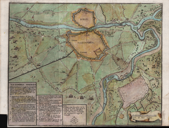
The graphic representation of the city of Alessandria, and of the borough of [[Bergoglio (Alessandria)|Bergoglio]] (or Borgoglio), enclosed within its own fortifications capable of withstanding intense assaults, is described in detail by Pert through the outlining of its most characteristic elements
The graphic representation of the city of Alessandria, and of the borough of [[Bergoglio (Alessandria)|Bergoglio]] (or Borgoglio), enclosed within its own fortifications capable of withstanding intense assaults, is described in detail by Pert through the outlining of its most characteristic elements
This work is not configured as a technical drawing or survey, like other examples of representations of Alexandria between the 16th and 18th centuries, but rather as a real war scenography, where the emphasis is placed on the representation of battalions, camps and war devices, with the aim of fixing in memory an era of significant historical tension.{{efn|The sixteenth century saw the rise of the theme of warfare, a phenomenon that became particularly consolidated and widespread between the seventeenth and eighteenth centuries , especially in Germany and France . The focus of urban portraits extended beyond the defensive apparatus, also embracing the celebration of battles and the representation of the deployment of military forces. These subjects began to characterize prints and loose sheets, contributing to the creation of true atlases through the reworking of once-confidential but now obsolete documents, which were standardized in format and representational technique. The siege emerged as a particularly relevant iconographic motif, offering insights into strategic aspects, military engineering, the architecture of fortifications, urban configuration, and defensive strategies. The impact of the siege on the surrounding territory became a crucial element of analysis, highlighting how war operations, often protracted and cyclically repeated, profoundly altered the environment, transforming cultivated fields, pastures, and communication routes into militarized spaces, with dramatic consequences for daily life. Artistic representations of sieges ranging from tapestries, frescoes, and bas-reliefs to watercolors, engravings, and prints often originate in the technical drawings of military engineers, transforming defensive schemes and tactical deployments into visual testimonies of epic episodes. In the 17th century, sieges assumed a central role in warfare, marking a clear evolution from the heroic conception of combat typical of the Middle Ages, based primarily on direct confrontation. This transformation radically influenced the art of war and, consequently, the morphology of urban fortifications.}}
This work is not configured as a technical drawing or survey, like other examples of representations of Alexandria between the 16th and 18th centuries, but rather as a real war scenography{{efn|The sixteenth century saw the rise of the theme of warfare, a phenomenon that became particularly consolidated and widespread between the seventeenth and eighteenth centuries , especially in Germany and France . The focus of urban portraits extended beyond the defensive apparatus, also embracing the celebration of battles and the representation of the deployment of military forces. These subjects began to characterize prints and loose sheets, contributing to the creation of true atlases through the reworking of once-confidential but now obsolete documents, which were standardized in format and representational technique. The siege emerged as a particularly relevant iconographic motif, offering insights into strategic aspects, military engineering, the architecture of fortifications, urban configuration, and defensive strategies. The impact of the siege on the surrounding territory became a crucial element of analysis, highlighting how war operations, often protracted and cyclically repeated, profoundly altered the environment, transforming cultivated fields, pastures, and communication routes into militarized spaces, with dramatic consequences for daily life. Artistic representations of sieges ranging from tapestries, frescoes, and bas-reliefs to watercolors, engravings, and prints often originate in the technical drawings of military engineers, transforming defensive schemes and tactical deployments into visual testimonies of epic episodes. In the 17th century, sieges assumed a central role in warfare, marking a clear evolution from the heroic conception of combat typical of the Middle Ages, based primarily on direct confrontation. This transformation radically influenced the art of war and, consequently, the morphology of urban fortifications.}}
==Notes==
==Notes==
{{Notelist}}
{{Notelist}}
| Siege of Alexandria (1657) | |
|---|---|
| Part of Franco-Spanish War (1635–1659) | |
.png) Anonymous, Alessandria, besieged by the French forces on 17 July 1657 with operations carried out by the Catholic and Austrian armies, the latter commanded by the Duke of Mantua, and the former by the Count of Fuensaldagna for the liberation of the said city, which took place on 19 August of the same year, etching on hand-coloured laid paper, 1657 , National Library of France, Paris. |
|
| Belligerents | |
| Commanders and leaders | |
|
Prince of Conti Francesco I d’Este Gianfranco Villa Gabriele of Savoy |
Charles II Gonzaga Alfonso Pérez de Vivero Gian Galeazzo Trotti Ferdinando Ravanal |
| Strength | |
| 15,000 infantry | |


Siege of Alexandria (1657) (Europe) |
|
Historical Context
In 1657, the walls of Alessandria were the scene of a significant episode in the European wars of the 17th century, when the armies of the major powers faced each other in what was one of the final chapters of the long and bloody conflict that devastated northern Italy. The region had become a crossroads of strategic interests for the great powers and their allies, engaged in a constant struggle for European dominance. In this context, the last decades had seen an intensification of hostilities on a continental scale, with France and Spain at the centre of a confrontation that also directly involved the State of Milan, under Spanish influence, and the Duchy of Savoy, by now openly siding with France. The siege took place in the final phase of the Franco-Spanish War, fought from 1635 to 1659. The initial phases arose with France’s entry into the Thirty Years’ War, in which Spain was already participating. The conflict between the two kingdoms continued for eleven years after the Peace of Westphalia , which ended the Thirty Years’ War, and was then concluded with the Peace of the Pyrenees.
The border areas, where cities and territories of crucial strategic importance were located, had been the scene of continuous clashes: prolonged sieges, conquests and reconquests had followed one another in a series of military operations that had put the local populations to the test. Previously absorbed into the sphere of Spanish influence, Alexandria is part of these border areas and became a strategic crossroads in the dispute for continental control.
In this scenario, the art of military engineering took on a fundamental role: both the Savoy and Spain employed their best engineers in the design and strengthening of the fortresses. The strategic vision that guided these operations was that of creating a network of fortified cities, connected to each other like “links in a chain”, according to the expression of Busca. This conception aimed to ensure an effective defence of the territory and to achieve an advantageous position with respect to the adversaries, in an era in which the control of the territory and the ability to defend it were essential for the survival and expansion of the states.
In 1655 , Carlo Morello from Pavia, a military engineer in the service of the Duchy of Savoy, observed that « many surprises have been attempted there although none have succeeded and therefore it is very difficult to attack it, since the Tanaro river passes through it and it is necessary to divide the army and therefore two bridges over the aforementioned river would be needed in case of a siege lasting two or three months ». Morello underlined how this characteristic required the division of the besieging forces and the need to build two bridges over the river to guarantee an effective siege lasting two or three months. However, the frequent flooding of the surrounding areas further complicated military operations, making the stability of a camp precarious and putting at risk the integrity of the temporary bridges, vulnerable to the destructive force of the waters and the debris carried by the current.
To further contextualize the siege of Alessandria, it is worth remembering that Francesco I d’Este, Duke of Modena, recognized as one of the most skilled commanders of his period and general of the Sun King, agreed with the Duke of Savoy to lead the Franco-Savoyard forces in a campaign aimed at inflicting a decisive blow to the Spanish and expelling them from Italy. Before reaching the Alessandria area, he advanced through the territory, his troops successively occupying several localities in the areas of Valsesia, Vercellese and Lomellina. Finally, they proceeded towards the Tanaro valley, where they managed to take control of Castello di Annone and Valenza.
These conditions led the Alexandrians to zealously prepare the entire defensive system. Count Alfonso Perez de Vivero, commander of the Spanish army, carefully visited the city’s fortifications, carrying out the necessary work to resist enemy assaults; the governor of Alexandria, Don Ferdinando Garcia Ravanal, promptly and abundantly provided for the city’s provisions.
Cartography
The graphic representation of the city of Alessandria, and of the borough of Bergoglio (or Borgoglio), enclosed within its own fortifications capable of withstanding intense assaults, is described in detail by Pert through the outlining of its most characteristic elements
This work is not configured as a technical drawing or survey, like other examples of representations of Alexandria between the 16th and 18th centuries, but rather as a real war scenography[a], where the emphasis is placed on the representation of battalions, camps and war devices, with the aim of fixing in memory an era of significant historical tension.
Notes
- ^ The sixteenth century saw the rise of the theme of warfare, a phenomenon that became particularly consolidated and widespread between the seventeenth and eighteenth centuries , especially in Germany and France . The focus of urban portraits extended beyond the defensive apparatus, also embracing the celebration of battles and the representation of the deployment of military forces. These subjects began to characterize prints and loose sheets, contributing to the creation of true atlases through the reworking of once-confidential but now obsolete documents, which were standardized in format and representational technique. The siege emerged as a particularly relevant iconographic motif, offering insights into strategic aspects, military engineering, the architecture of fortifications, urban configuration, and defensive strategies. The impact of the siege on the surrounding territory became a crucial element of analysis, highlighting how war operations, often protracted and cyclically repeated, profoundly altered the environment, transforming cultivated fields, pastures, and communication routes into militarized spaces, with dramatic consequences for daily life. Artistic representations of sieges ranging from tapestries, frescoes, and bas-reliefs to watercolors, engravings, and prints often originate in the technical drawings of military engineers, transforming defensive schemes and tactical deployments into visual testimonies of epic episodes. In the 17th century, sieges assumed a central role in warfare, marking a clear evolution from the heroic conception of combat typical of the Middle Ages, based primarily on direct confrontation. This transformation radically influenced the art of war and, consequently, the morphology of urban fortifications.

