
A devastating [[1826 Red River flood|flood destroyed Fort Garry in 1826]], prompting the Company’s then-governor, [[George Simpson (administrator)|George Simpson]], to search for a safer location down river. Governor Simpson chose the site of Lower Fort Garry because of its high ground and location below the St. Andrew’s Rapids, eliminating a time-consuming portage of heavy fur packs and [[York boat]]s. However, the fort never became the administrative centre it was intended, since most of the population of the area was centred near [[The Forks, Winnipeg|The Forks]] and objected to the extra travel required to do business at the new fort. As a result, [[Upper Fort Garry]] was rebuilt in stone at [[The Forks, Winnipeg|The Forks]], very near the original Fort Garry site.
A devastating [[1826 Red River flood|flood destroyed Fort Garry in 1826]], prompting the Company’s then-governor, [[George Simpson (administrator)|George Simpson]], to search for a safer location down river. Governor Simpson chose the site of Lower Fort Garry because of its high ground and location below the St. Andrew’s Rapids, eliminating a time-consuming portage of heavy fur packs and [[York boat]]s. However, the fort never became the administrative centre it was intended, since most of the population of the area was centred near [[The Forks, Winnipeg|The Forks]] and objected to the extra travel required to do business at the new fort. As a result, [[Upper Fort Garry]] was rebuilt in stone at [[The Forks, Winnipeg|The Forks]], very near the original Fort Garry site.
== History ==
=== Indigenous landscape before the fort ===
<!– Long-standing Indigenous use of the Red River corridor
Seasonal mobility, trade, diplomacy, subsistence
Anishinaabe, Swampy Cree, and Métis presence
Pre-contact and early contact period –>
=== Establishment of Lower Fort Garry (1830s) ===
<!– Hudson’s Bay Company decision to relocate from Upper Fort Garry
Site selection and construction
Shift from wooden posts to stone architecture
Early functions and strategic purpose –>
=== Fur trade operations and regional administration ===
<!– Role as an HBC provisioning and administrative centre
Labour, trade, and supply networks
Relationships with Indigenous and Métis communities
Daily operations and economic function –>
=== Spatial control and colonial authority ===
<!– Fort design as governance infrastructure
Regulation of movement, labour, and access
Emerging hierarchy of space and power
Relationship to surrounding settlement patterns –>
=== Treaty No. 1 and treaty-making at Lower Fort Garry (1871) ===
<!– Context of treaty-making in the Red River region
Indigenous leaders and Crown representatives
Why Lower Fort Garry was chosen as the signing location
Differences in treaty understandings –>
=== After Treaty No. 1: transition and consequences ===
<!– Administrative and land-use changes after 1871
Reserve confinement and altered mobility
Changes in labour and provisioning
Decline of Indigenous domestic presence at the site –>
=== Later nineteenth-century use ===
<!– Continued colonial administration
Agricultural and industrial functions
Role within Manitoba and the expanding Canadian state –>
=== Twentieth-century decline and preservation ===
<!– Reduced operational importance
Preservation efforts
Designation as a historic site
Early interpretation approaches –>
=== Interpretation, commemoration, and reassessment ===
<!– Parks Canada stewardship
Evolving interpretation of Indigenous history and treaties
Public memory, education, and debate
Relationship to contemporary Treaty 1 Nations –>
==History==
==History==
Training of [[North-West Mounted Police]] members took place at the fort in the winter of 1873–1874. Many of the North-West Mounted Police of 1873–74 had been there already during the rebellion in 1870, including Inspector [[James F. MacLeod]], who had met his fiancée, Mary Drever, at Lower Fort Garry on the previous trip. The first contingent of Mounties arrived in Lower Fort Garry on October 22, 1873, and on November 3 they were sworn in and commenced training. The bitter winter was spent drilling and learning to ride. The parade ground was frozen as hard as concrete, and was pretty unforgiving when a recruit was unexpectedly pitched from his horse. By the following June they were caught up in preparations for the arrival of Commissioner [[George Arthur French|G.A. French]] and the other divisions, and headed out to meet them at [[Fort Dufferin]]. The fort was turned over once again to the [[Canadian Militia]].
Training of [[North-West Mounted Police]] members took place at the fort in the winter of 1873–1874. Many of the North-West Mounted Police of 1873–74 had been there already during the rebellion in 1870, including Inspector [[James F. MacLeod]], who had met his fiancée, Mary Drever, at Lower Fort Garry on the previous trip. The first contingent of Mounties arrived in Lower Fort Garry on October 22, 1873, and on November 3 they were sworn in and commenced training. The bitter winter was spent drilling and learning to ride. The parade ground was frozen as hard as concrete, and was pretty unforgiving when a recruit was unexpectedly pitched from his horse. By the following June they were caught up in preparations for the arrival of Commissioner [[George Arthur French|G.A. French]] and the other divisions, and headed out to meet them at [[Fort Dufferin]]. The fort was turned over once again to the [[Canadian Militia]].
===Recent history (1885–present)===
===Recent history
[[File:Lower Fort Garry, St. Andrews (420191) (9442137711).jpg|thumb|Between May and September, the Fort is used as a [[living museum]], with [[historical reenactment|re-enactors]] recreating life in the 1850s.]]
[[File:Lower Fort Garry, St. Andrews (420191) (9442137711).jpg|thumb|Between May and September, the Fort is used as a [[living museum]], with [[historical reenactment|re-enactors]] recreating life in the 1850s.]]
The fort has also been a penitentiary, a mental hospital (1885–1886), an HBC residence, and a golf course/motor country club (1911–1963). One of the mental hospital’s most infamous residents was [[Honoré Jackson|Honoré Jaxon]], Louis Riel’s secretary who was found not guilty of treason by reason of insanity after the [[North-West Rebellion]].
The fort has also been a penitentiary, a mental hospital (1885–1886), an HBC residence, and a golf course/motor country club (1911–1963). One of the mental hospital’s most infamous residents was [[Honoré Jackson|Honoré Jaxon]], Louis Riel’s secretary who was found not guilty of treason by reason of insanity after the [[North-West Rebellion]].
Historic fort in St. Andrews, Manitoba, Canada
Lower Fort Garry was built in 1830 by the Hudson’s Bay Company on the western bank of the Red River, 20 mi (32 km) north of the original Fort Garry (now in Winnipeg, Manitoba, Canada). Treaty 1 was signed there.
A devastating flood destroyed Fort Garry in 1826, prompting the Company’s then-governor, George Simpson, to search for a safer location down river. Governor Simpson chose the site of Lower Fort Garry because of its high ground and location below the St. Andrew’s Rapids, eliminating a time-consuming portage of heavy fur packs and York boats. However, the fort never became the administrative centre it was intended, since most of the population of the area was centred near The Forks and objected to the extra travel required to do business at the new fort. As a result, Upper Fort Garry was rebuilt in stone at The Forks, very near the original Fort Garry site.
Indigenous landscape before the fort
[edit]
Establishment of Lower Fort Garry (1830s)
[edit]
Fur trade operations and regional administration
[edit]
Spatial control and colonial authority
[edit]
Treaty No. 1 and treaty-making at Lower Fort Garry (1871)
[edit]
After Treaty No. 1: transition and consequences
[edit]
Later nineteenth-century use
[edit]
Twentieth-century decline and preservation
[edit]
Interpretation, commemoration, and reassessment
[edit]
Early 19th century (1830–1850)
[edit]
The first buildings built at the fort in 1830 were the “fur loft”, which housed the company store, small warehouse and trader’s office, and the “Big House” (residence for the governor of the Hudson’s Bay Company (HBC) or other high-ranking officials). Later additions included a warehouse and a men’s house. The fort’s signature walls were completed in the 1840s, adding an icehouse, powder magazine, bakehouse, and warehouse bastions. These walls were non-military, intended only to make the fort appear more important and impressive to both local traders and visiting HBC officers. Many of the buildings were constructed with limestone, which was easily obtained from nearby. The site also hosts excellent examples of Red River Frame construction (Farm Manager’s House) and Half-timbered construction (colombage pierroté) (Men’s House and Big House Annex).
Although the Lower Fort did trade a small amount of furs, its main purpose was as a supply depot for the Red River settlement and the surrounding Cree, Anishinaabe, Métis, and European (mostly Orkney Scot) populations. Many furs at the fort were brought from other districts, repackaged at the fort and sent to England via York Factory. The post traded essential manufactured goods to the farmers and hunters for produce that was in turn used for provisioning company treks into the north.
_(9446656970).jpg)
Every now and then there was a crisis that called for military action, and Lower Fort Garry was the obvious choice for a base of operations. In 1846, British troops (6th Regiment of the Foot) were sent to the fort when a dispute erupted with the United States over the boundary between the Oregon Territory and what is now British Columbia. However, some believe the request for troops was actually intended to intimidate local free traders (as trading with anyone other than the HBC was illegal). In either case, by the time the troops arrived (1846), the threat of invasion was long over. The troops (becoming a nuisance by causing minor disturbances) were put to work at the fort completing the construction of the walls which were finished in 1848.
Mid 19th century (1851–1884)
[edit]
The fort became an industrial centre by the 1860s and included several buildings, such as a flour mill, sawmill, forge, and a brewery. When the Red River Rebellion broke out in 1870, Louis Riel occupied Upper Fort Garry, and the Quebec Rifles took the lower fort. No wars or fights ever occurred at Lower Fort Garry as it was a peaceful settlement.
On August 3, 1871, the first treaty in Western Canada was established between the federal government and seven chiefs of the Ojibway (Saulteaux) and Swampy Cree First Nations at Lower Fort Garry. Indian Treaty No. 1 transferred the land that now comprises part of modern Manitoba. The treaty’s intent was to ensure the peaceful settlement of the prairies by European immigrants, while providing First Nations people with land, access to resources and other necessities for their survival. Almost immediately after the treaty was established, the two parties disagreed on its meaning.
Indian Treaty No. 1, the precedent for the 10 subsequent numbered treaties in Western Canada, is commemorated by a Historic Sites and Monuments Board of Canada plaque outside the Visitor Reception Centre.
Training of North-West Mounted Police members took place at the fort in the winter of 1873–1874. Many of the North-West Mounted Police of 1873–74 had been there already during the rebellion in 1870, including Inspector James F. MacLeod, who had met his fiancée, Mary Drever, at Lower Fort Garry on the previous trip. The first contingent of Mounties arrived in Lower Fort Garry on October 22, 1873, and on November 3 they were sworn in and commenced training. The bitter winter was spent drilling and learning to ride. The parade ground was frozen as hard as concrete, and was pretty unforgiving when a recruit was unexpectedly pitched from his horse. By the following June they were caught up in preparations for the arrival of Commissioner G.A. French and the other divisions, and headed out to meet them at Fort Dufferin. The fort was turned over once again to the Canadian Militia.
===Recent history
_(9442137711).jpg)
The fort has also been a penitentiary, a mental hospital (1885–1886), an HBC residence, and a golf course/motor country club (1911–1963). One of the mental hospital’s most infamous residents was Honoré Jaxon, Louis Riel’s secretary who was found not guilty of treason by reason of insanity after the North-West Rebellion.
The Historic Sites and Monuments Board installed a plaque to commemorate the fort’s status as a historic site in 1929.[1] The HBC owned the fort until 1951, when it was given to the federal government. The site was designated a National Historic Site in 1958,[2] and named one of the top 10 National Historic Sites in the country in 2011 by Canada’s History magazine.[3] Between May and September, costumed interpreters recreate life at Lower Fort Garry in the early 1850s when Eden Colvile was inland governor of the HBC and in residence at the fort. Original buildings and walls, hands on activities, as well as original-to-era furnishings enhance the visitor experience.
Lower Fort Garry is situated on the west bank of the Red River in what is now the Rural Municipality of St. Andrews, north of Winnipeg. The site occupies elevated ground above the river, a location that offered relative protection from flooding, access to water-based transportation, and oversight of movement along a key regional corridor connecting Lake Winnipeg to the southern prairies.
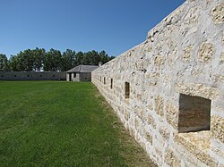
The fort complex was constructed in the 1830s as a permanent Hudson’s Bay Company establishment, replacing the earlier Upper Fort Garry at The Forks as the company’s primary regional depot and administrative centre. Unlike earlier wooden trading posts, Lower Fort Garry was built largely of limestone and designed as a fully enclosed compound, reflecting a shift toward permanence, defensibility, and centralized control. Thick stone walls enclose a rectangular courtyard containing workshops, storage buildings, administrative spaces, and domestic quarters.
The internal layout of the site reflects a hierarchical organization of space. Industrial and service functions, including blacksmithing, baking, storage, and repair, were concentrated within the walls, while administrative and residential areas reinforced divisions of rank and labour. Circulation within the compound was tightly controlled, and the fortified design limited informal access and movement, distinguishing the fort from surrounding Indigenous and Métis settlement patterns that emphasized mobility and relational use of land.
Beyond the walls, the site was historically connected to a broader landscape shaped by river travel, seasonal movement, and trade networks. Paths, landing areas, and work zones outside the fort facilitated the movement of goods, people, and supplies, linking the compound to Indigenous, Métis, and settler communities throughout the Red River region. These external spaces were integral to the fort’s operation, even though they are less visibly preserved than the stone structures themselves.
Following the signing of Treaty No. 1 in 1871, the function of the site increasingly reflected colonial administrative priorities, including provisioning, regulation, and land management. As Indigenous mobility and access to space became more constrained in the treaty era, the fort’s role shifted further toward fixed governance and oversight within the emerging provincial and national framework.
Today, the site is preserved as a National Historic Site of Canada. The surviving stone buildings, walls, and open spaces provide physical evidence of nineteenth-century colonial planning and industrial activity, while also occupying land with a much longer Indigenous history. The site’s preservation reflects both its architectural durability and its symbolic significance within Canadian narratives of expansion, treaty-making, and governance, positioning Lower Fort Garry as a place where layered histories continue to intersect.
Lower Fort Garry occupies a designated National Historic Site located on the west bank of the Red River in the Rural Municipality of St. Andrews, north of Winnipeg. The protected site encompasses both a fortified stone compound and surrounding open grounds historically associated with access, labour, and river-based transportation.
The fortified core of the site consists of a fully enclosed limestone compound arranged around a central rectangular courtyard. Thick stone walls define the perimeter of the fort, creating a controlled interior space that housed workshops, storage facilities, administrative rooms, and domestic quarters. The scale and durability of the stone construction reflect a deliberate shift from earlier wooden trading posts toward permanence, defensibility, and centralized authority.
Within the walls, multiple nineteenth-century buildings survive, each constructed for specific operational purposes. These include facilities for food production and storage, blacksmithing and repair, warehousing, and administration, as well as residential spaces associated with the Hudson’s Bay Company workforce. The internal layout reinforced functional separation and social hierarchy, with circulation structured to regulate movement within the compound.
The stone-walled fort occupies only a portion of the broader historic landscape. Outside the walls, the site historically included work areas, paths, and river landing points that connected the fort to regional trade networks and surrounding Indigenous and Métis communities. These exterior spaces were essential to the operation of the fort, facilitating the movement of goods, supplies, and people along the Red River corridor.
The site is situated on elevated ground above the river, reducing flood risk while maintaining direct access to water transport. This positioning allowed for oversight of river traffic and contributed to the fort’s role as an administrative and provisioning centre. Views along the river and across surrounding terrain formed part of the fort’s spatial logic, supporting both logistical control and symbolic authority.
Today, the site retains a high degree of integrity, with surviving stone walls, buildings, and spatial organization conveying the scale and function of the original compound. Preserved open areas surrounding the fort provide context for understanding how the fortified core operated within a larger cultural landscape shaped by long-term Indigenous use, fur trade logistics, and nineteenth-century colonial governance.
Archaeological evidence demonstrates that the landscape surrounding Lower Fort Garry was part of a long-occupied Indigenous cultural corridor long before the construction of the fort in the 1830s. The Red River and adjacent waterways supported seasonal movement, trade, and subsistence activities for thousands of years, leaving a dispersed archaeological record of campsites, food processing areas, and tool production rather than dense, permanent settlements.
Pre-fort archaeological materials recovered in the broader Red River region include stone tools, hearth features, and faunal remains associated with hunting, fishing, and food preparation. These findings reflect patterns of mobility and repeated short-term occupation characteristic of Indigenous land use in southern Manitoba, in which access to waterways, seasonal resources, and regional networks was central. The absence of large, permanent structures in the archaeological record does not indicate a lack of use, but rather different cultural relationships to land and settlement.
Archaeology at Lower Fort Garry documents a marked transformation of the landscape following European construction. The establishment of a permanent stone fort introduced fixed architecture, industrial activity, and altered land use, including quarrying, drainage modification, and the creation of enclosed work and storage spaces. Excavations within the fort have identified foundations, work areas, refuse deposits, and material remains associated with carpentry, blacksmithing, food preparation, and storage, reflecting the fort’s role as an administrative, provisioning, and labour centre.
Indigenous material remains have also been identified in contexts adjacent to and beneath fort-period deposits, indicating continued Indigenous presence and interaction in the area following construction. These findings support historical evidence that Indigenous peoples maintained economic, labour, and trading relationships with the fort, even as access to space and movement became increasingly constrained during the nineteenth century.
Archaeological evidence does not record the signing of Treaty No. 1 as a discrete material event. Instead, the archaeological record reflects the outcomes that followed treaty-making, including intensified colonial infrastructure, expanded agricultural activity, and a decline in visible Indigenous domestic occupation within the immediate fort precinct. These shifts are consistent with broader patterns of reserve confinement, administrative centralization, and changing land use in the region after 1871.
Together, archaeological findings situate Lower Fort Garry within a much deeper Indigenous landscape and document the physical transformation of that landscape under colonial administration. The evidence highlights continuity, disruption, and adaptation over time, demonstrating that the fort was not an isolated starting point but part of a long sequence of human occupation shaped by changing relationships to land, authority, and mobility.
Designations and recognition
[edit]
Lower Fort Garry has received multiple forms of official recognition that reflect its architectural integrity, historical significance, and continuing role in the interpretation of nineteenth-century colonial administration and treaty-making in western Canada.
The site was designated a National Historic Site of Canada, formally recognizing its importance to Canadian history at the national level. This designation acknowledges Lower Fort Garry’s associations with the Hudson’s Bay Company, its role as a major administrative and provisioning centre in the Red River region, and its connection to the signing of Treaty No. 1 in 1871. National Historic Site status places the fort within Canada’s federal heritage framework and subjects it to long-term conservation and interpretive standards.
In addition to its national designation, the site has been recognized through heritage conservation measures that protect its surviving stone buildings, walls, and spatial layout. These protections emphasize the architectural durability of the limestone construction and the integrity of the fortified compound, distinguishing Lower Fort Garry as one of the most intact nineteenth-century stone fur-trade complexes in western Canada.
Lower Fort Garry has also been formally interpreted and managed as a heritage site by Parks Canada, situating it within a broader network of protected places intended to represent key themes in Canadian history. Interpretation at the site has evolved over time, reflecting changing approaches to the presentation of fur trade history, colonial governance, and treaty relationships. This ongoing reassessment forms part of a wider national effort to address the complexity of Indigenous–Crown relations within historic site interpretation.
The fort has been included in provincial and regional heritage inventories and has been referenced in historical and archaeological studies relating to the Red River Settlement, treaty-making, and early industrial infrastructure in Manitoba. Its preservation has made it a focal point for academic research, public education, and heritage tourism, and it is frequently cited in discussions of early colonial planning and administration in the Prairies.
Over time, Lower Fort Garry has also been recognized in public discourse, education programming, and media coverage as a site of layered and contested history. These forms of recognition extend beyond formal designation, reflecting ongoing public interest in the site’s relationship to Indigenous history, Treaty No. 1, and the legacy of colonial expansion in Manitoba.
Together, these designations and forms of recognition situate Lower Fort Garry as both a protected heritage asset and a continuing site of historical interpretation, where official commemoration, public memory, and evolving historical understanding intersect.

