


L’Ecot (French: L’Écot) is a small mountain hamlet located in the commune of Bonneval-sur-Arc, in the Haute Maurienne Valley, Savoie, southeastern France. Located at about 2,000 m above sea level, it lies roughly 4 km by path from Bonneval-sur-Arc.[1] The hamlet is known for its intact Alpine stone houses and traditional mountain setting. It has been classified as a protected site since 1971 due to its remarkably well-preserved mountain architecture.[2] L’Ecot is also part of the Parc national de la Vanoise.
The toponym L’Ecot derives from the French word écot, which is attested as early as the Middle Ages, under the form escot, referring to a “contribution or share to be paid in a collective expense.” This term has origins in several languages, Walloon sico, Provencal escot, Spanish and Italian escote, late Latin scotum, and Old Germanic scot, all of which are connected to the concept of sharing, division, or communal responsibility.[1]
In addition to its fiscal meaning, in the context of Alpine and Franco-Provençal toponymy, the word écot or escot could also designate a cleared or cultivated area, meaning land that has been prepared for agriculture or pasture after the removal of forest or shrubs. This interpretation is supported by the traditional use of similar terms in Savoie and neighbouring Alpine regions, where they frequently appear in local place names to indicate small hamlets, pastures, or cultivated plots of land in mountainous terrain.
Given the historical context of mountain settlements and pastoral activity in Haute-Maurienne, the name of the hamlet L’Ecot could reflect either the idea of a share to pay, associated with communal obligations, or, more likely, the identification of land that had been cleared for human habitation or livestock grazing. Such cleared spaces were often located for their accessibility to pastures and protection from harsh alpine conditions. In the absence of direct historical documentation for this particular hamlet, this etymological explanation remains hypothetical, though it aligns with broader patterns observed in the naming of Alpine settlements and agricultural sites.[3]
Archaeological traces such as cupules on glacially polished rocks show that humans used the area long before the Middle Ages. Local histories also report that Piedmontese shepherds began using the pastures in early medieval times.[4]
During the Second World War, the hamlet of L’Écot, like the rest of Haute Maurienne, was affected by the conflict. Located near the Col de l’Iseran, close to the Italian border, which forms a strategic passage between Haute Maurienne and Haute Tarentaise, the hamlet was in area of military importance. The valley was occupied by Italian forces from 1940 to 1943, and then by the German army until its liberation in 1944.[5]
The hamlet was inhabited year-round until the mid-20th century; after the 1950s and 1960s, many houses were only used seasonally, until restoration and renewed occupation began in recent decades.[3]
L’Ecot lies amid several notable settlements. The closest is Bonneval-sur-Arc, just 2 km away, a small alpine village of about 300 inhabitants that administers the hamlet within its municipal boundaries. Some 20 km down the valley is Val-Cenis, a major resort community in the upper Maurienne, comprising several villages and home to roughly 2,000 residents. Further along the Arc valley, Modane, about 45 km from L’Ecot, forms the principal urban centre of the upper Maurienne region. The hamlet is located at the end of the departmental road D902, which continues beyond Bonneval-sur-Arc. During winter, access is generally closed due to snow, and the hamlet can only be reached on foot or on skies. During summer, to limit the negative impact of tourism on the natural environment, road access to the hamlet is regulated. The road leading from Bonneval-sur-Arc is subject to limited traffic. Nonetheless, a shuttle service connects Bonneval-sur-Arc to L’Ecot during the tourist season.[6] Several marked trails, including the Sentier des Agneaux, allows visitors to explore the area, promoting environmentally friendly tourism. The hamlet lies near the sources of the Arcand is surrounded by several high peaks of the Vanoise Massif, including the Albaron (3,638 m) and the Ouille Noire (3,364 m).[7][8] The site is also part of an awareness-raising policy led by the local tourist office, in collaboration with the Vanoise National Park, as part of a sustainable tourism initiative.[9]
Transhumance and Pastoral heritage
[edit]
L’Ecot was one of the traditional regions in the French Alps used for seasonal livestock movement, forming part of the region’s historic transhumance system. These designated areas were exclusively allocated for grazing herds during the summer season, facilitating farmers’ efficient utilisation of high-altitude pastures while simultaneously conserving lower valley fields for the purpose of crop cultivation.[10]
The organisational structure of L’Ecot embodies the enduring pastoral legacy of the Maurienne and Tarentaise regions, where communal stewardship of grazing land fostered sustainable livestock management practices.[11] This seasonal rhythm influenced the architecture of L’Ecot. Houses were built closer together for warmth and preservation of livestock. Dry-wall enclosures, walkways and barns are still visible to this day to reflect the use of ancient pastoral traditions.[12]
Although pastoralism on a large scale declined in the 20th century, transhumance remains symbolically and ecologically significant. The Vanoise National Park and the Haute-Maurienne Tourist Office support projects that promote pastoral heritage, guided walks, and awareness events about traditional herding practices.[13] Seasonal shepherds and animateurs pastoraux now work with the park to balance tourism, conservation, and grazing.[14]
The climate at the hamlet of L’Ecot may vary due to its high altitude and mountain setting. More precise climate information is available at the nearby commune of Bonneval-sur-Arc, approximately 4 km away.[15]
| Climate data for Bonneval-sur-Arc | |||||||||||||
|---|---|---|---|---|---|---|---|---|---|---|---|---|---|
| Month | Jan | Feb | Mar | Apr | May | Jun | Jul | Aug | Sep | Oct | Nov | Dec | Year |
| Mean daily maximum °C (°F) | −2 (28) |
0 (32) |
4 (39) |
7 (45) |
12 (54) |
17 (63) |
19 (66) |
18 (64) |
14 (57) |
10 (50) |
3 (37) |
−1 (30) |
8 (47) |
| Mean daily minimum °C (°F) | −8 (18) |
−6 (21) |
−3 (27) |
0 (32) |
4 (39) |
9 (48) |
11 (52) |
10 (50) |
7 (45) |
3 (37) |
−3 (27) |
−7 (19) |
1 (35) |
| Average precipitation mm (inches) | 110 (4.3) |
95 (3.7) |
100 (3.9) |
120 (4.7) |
140 (5.5) |
150 (5.9) |
140 (5.5) |
130 (5.1) |
120 (4.7) |
110 (4.3) |
100 (3.9) |
110 (4.3) |
1,425 (55.8) |
| Average snowy days | 14.5 | 12.5 | 14.7 | 15.1 | 10.4 | 1.7 | 0.6 | 0.6 | 3.2 | 8.2 | 14.5 | 14.2 | 110.2 |
| Average relative humidity (%) | 89 | 90 | 92 | 90 | 91 | 86 | 81 | 80 | 85 | 88 | 94 | 83 | 87 |
| Mean monthly sunshine hours | 9.2 | 10.3 | 11.9 | 13.5 | 14.9 | 15.6 | 15.3 | 14.1 | 12.6 | 11.0 | 9.6 | 8.8 | 146.8 |
| Source: Meteoblue – Climate Data (ERA5T, 1792 m) • Bonneval-sur-Arc Daylength & Humidity – Wanderlog | |||||||||||||
L’Ecot retains a typical mountain style, characterised by compact houses and narrow cobbled streets that follow the natural slope of the mountain itself. The houses are built close together to limit exposure to the wind and cold. They were built according to the orientation of the sun: only the main façades, facing south, have openings to maximize solar heat, while the north façades remain closed to prevent heat loss.[16]
The houses are built from local materials, specifically gneiss or schist stone for the walls and slate for the roofing. Each house is organized into three distinct levels: a ground floor, an upper floor and an attic. These three floors had specific functions. The ground floor was used for agricultural purposes: it housed livestock during the night and in winter and was used to store equipment. The heat produced by the animals helped to warm the upper floor. Accessible via a ramp or a staircase made from local stone, the upper floor was dedicated to everyday life and comprised the kitchen, living room and more bedrooms. The attic, located beneath the roof, was used to store hay and provisions, such as food or seeds for farming.[17]
Each house had a terrace, laid out as small plots of arable land, which were used to grow hardy cereals such as rye and barley, as well as vegetables. The limited size reflects the difficulty of cultivating land at high altitude. The terraces were designed to retain soil and moisture, reducing the risk of erosion and landslides around the dwellings. Some were used as outdoor workspaces, particularly for drying laundry or storing hay for livestock.[17]
The Saint-Margaret chapel
[edit]
.JPG)
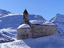
The Saint-Margaret Chapel is located in the hamlet of L’Ecot, overlooking it from a small hill. It was built using local materials, including gneiss or schist for the walls, a slate roof, and larch wood framing and doors. A small bell tower surmounts the façade, housing a bell that is rare in small hamlets of this type. The chapel is estimated to have been built around the 12th century, as suggested by its semi-circular apse and medieval frescoes, a characteristic of the Alpine Romanesque style. Ecclesiastical documents dating from the 15th century mention the chapel, attesting to its age.[18]

The frescoes, discovered in the 19th century, depict the life of Saint Margaret of Antioch — a virgin martyr who, according to legend, emerged from the belly of a dragon that had swallowed her. People still prayed to her, particularly for childbirth and the pains experienced by pregnant women. These frescoes are now invisible, covered by a 19th-century whitewash. The chapel served as a place of worship for the inhabitants of the hamlet, as well as for shepherds and travellers passing through. On December 1, 1980, the Saint-Margaret Chapel was officially listed as a Monument historique by the French Ministry of Culture, through a ministerial decree recognizing its architectural and cultural significance within the Haute-Maurienne Valley. It is legally protected as part of France’s national heritage register.[19]
.JPG)
The hamlet of L’Écot lies close to the upper course of the Arc, which rises from glaciers in the Franco-Italian Alpine frontier and flows down the Haute Maurienne Valley. The river has helped shape the surrounding landscape, its bed, banks and adjacent wetlands form a variety of habitats, from alpine meadows to riparian zones, that support a rich range of plant and animal life.[20]
L’Ecot, located on the edge of the Vanoise National Park, is frequently viewed as a natural gateway for many. This proximity makes it a place where the flora and fauna are particularly rich and well preserved. The local flora is characterized by subalpine calcifuge vegetation. The surrounding high-altitude environment supports a variety of habitats, particularly acidic (non-calcareous) soils, which allow certain alpine plants such as Pink Stonecrop (Rhodiola rosea), Starling (Bupleurum stellatum), Stinkhorn Mushroom (Thalictrum foetidum), Tansy Ragwort (Hugueninia tanacetifolia) or even Ovoid Raiponce (Phyteuma halleri) to grow. The fauna of the area also includes several protected species that are emblematic of the Alps and the Vanoise National Park, such as the Alpine Ibex (Capra ibex), Black Grouse (lyrurus tetrix), or even Golden Eagle (Aquila chrysaetos).[21]
Such rich yet fragile biodiversity requires regular scientific monitoring. The hamlet and its surroundings are among the areas monitored by teams from the Vanoise National Park. This includes technicians specialising in wildlife (responsible for tagging, monitoring and capturing animals for scientific reasons) and park rangers who carry out botanical inventories and floristic surveys. These agents, who are part of the Park’s Knowledge and Management division, are responsible for preserving and studying alpine ecosystems.[22] Surveys are carried out several times a year, depending on the reproduction or flowering cycles specific to each species, and are the subject of multi-year observation series – often over a period of five years – in order to better understand habitat changes and the effects of climate change on fauna and flora.
Cultural Significance
[edit]
The award-winning films Belle and Sebastien (2013), Belle & Sebastien: The Adventure Continues (2015), and Belle and Sebastien: Friends for Life (2018), were filmed in the hamlet of L’Ecot. One of the movie directors, Nicolas Vanier, chose L’Ecot for its well-preserved cultural and architectural heritage, considering it an ideal setting for several key scenes.[23] After the release of the first film in 2013, it was a commercial success and sold more than three millions cinema tickets.[2] Apart from its cinematic associations, L’Ecot is also valued for its views within the Haute-Maurienne Vanoise area, part of the Parc Nationale de la Vanoise. Its views that include glacial cirques, wild animals and landscapes, attracts nature-lovers, tourists and families all year round. Its touristic appeal is also due to routes connecting L’Ecot with refuges and offering opportunities to enjoy the same views, making it an ideal site for a film to take place.[24]
Publicity from the Belle et Sébastien movies significantly increased cultural tourism in L’Ecot and the wider Haute-Maurienne Vanoise.[25] The Tourist Information Office then maximized the potential of this success by having guided tours of the location where the filming took place, offering tourists the possibility to experience the environment directly in the film and historical landscape of the region.[26] Families and enthusiasts are specifically drawn to seasonal programs that include nature walks, exhibitions and outdoor events influenced by the film, allowing them to experience this adventure through the perspective of Belle et Sébastien.[27] The cinematic legacy is brought into focus by a variety of heritage programs and festivals in the Haute-Maurienne Region. This includes the European Heritage Days and local film themed outdoor events featuring a film theme. [28]
Local Traditions and Folklore
[edit]
L’Ecot as well as the rest of the Haute-Maurienne are rich in local folklore that incorporates Christian traditions with traditional agricultural beliefs.[29] The little town is filled with tales of the devil, spirits and supernatural events, which relates to the environment’s apparent beauty and at the same time, peril. Many of these tales relate to the hamlet’s geographical features including; cairns, rivers, mountain passes and stone bridges – all of which are believed to have been carefully sculpted by supernatural entities. Churches and chapels which often showcase baroque treasures, which serve as celebration centres and spiritual grounds. Therefore, this strengthens the connections between the spiritual and everyday life. Folklore throughout the valley illustrate the challenges and resilience of the mountain people, their religious processions and yearly celebrations representing concrete manifestations of common principles.[30]
Both locals and visitors are drawn to the historic patterns of L’Ecot and the larger Haute-Maurienne region due to preservation initiatives that have maintained a tangible “time-stood-still” feeling. [31] Hiking trails that lead to the alpine headwaters of the Arc, for example offer a tour into local folklore along with natural beauty, with each site associated with religious theology and pastoral history.[30] The identity of L’Ecot and its surrounding villages is still shaped by these customs and beliefs which are passed down through oral tradition and communal gatherings.
Located at an altitude of around 2,000 m, the hamlet of L’Ecot is set in a high mountain environment, characterized by open mountain pastures and traditional dry stone architecture. The hamlet has largely retained its original landscape and the character of its old buildings. This site is an ideal starting point for hikers wishing to explore the Vanoise Massif. Several hiking trails are accessible from L’Ecot, notably those leading towards the Saint-Clair Bridge and a nearby waterfall, the Col des Évettes pass, and the Grand-Méan Glacier.[32] L’Ecot can also be the starting point for the Haute-Maurienne Traverse, a 55 km ski mountaineering route leading to Villarond.[33]
L’Ecot also offers direct access to the Vanoise National Park, making it a popular destination for outdoor enthusiasts and hikers. The hamlet offers few tourist services, including a restaurant located in an old farmhouse and a crêperie located in the upper part of the village.[34] One-off events are organized there during the summer, such as concerts as part of the “Scènes estivales” program, accompanied by eco-friendly stands. Several outdoor activities are offered, including accompanied canyoning trips. The hamlet receives an estimated 25,000 to 40,000 visitors annually, with its peak during the summer season.[35]
Geology and Natural Landscape
[edit]
The hamlet of L’Ecot lies within the upper Haute-Maurienne Valley, a region shaped primarily by Quaternary glacial activity and Alpine tectonics.[36] The surrounding mountains belong to the internal crystalline massifs of the Western Alps, composed mainly of gneiss, schist, quartzite, and mica schist formed during the Alpine orogeny between 40 and 25 million years ago.[37][38]These metamorphic rocks give the landscape its rugged appearance and provide the local materials traditionally used for building houses, roofs, and dry-stone walls.

During the last Ice Age, vast glaciers descending from the Vanoise Massif carved out the Arc Valley, forming a broad U-shaped glacial trough and leaving behind terraces and morainic deposits. L’Ecot itself is situated on one of these glacial terraces, above the modern Arc River, which continues to erode and rework these ancient sediments. The nearby Évettes and Grand-Méans glaciers, still visible from the hamlet, are remnants of this extensive glacial system. Their retreat over the past centuries has exposed polished bedrock, striations, and erratic boulders that mark former ice limits.[39]
The Arc, originating from the glaciers at the Franco-Italian frontier, has played a major geomorphological role in shaping the valley. Its upper course near L’Ecot is characterized by steep gradients, rapids, and braided channels, typical of alpine meltwater streams.[40] Seasonal snowmelt and glacier runoff contribute to rapid fluctuations in flow volume, which influence both soil erosion and the vegetation patterns of the surrounding slopes.
The landscape around the hamlet also shows evidence of periglacial and gravitational processes still active today. Freeze thaw cycles, common at altitudes around 2,000 m, produce rockfalls, scree slopes, and frost-heave formations.[41] Avalanches and snow creep further modify the mountain sides, while the accumulation of debris at the base of slopes creates fertile zones where alpine meadows develop. These dynamic processes are closely monitored within the Parc national de la Vanoise as indicators of ongoing geomorphological evolution in high-mountain environments.
The geology and topography of L’Écot directly influence its settlement pattern and architecture. The hamlet’s compact structure follows the natural slope of the glacial terrace, with buildings aligned on relatively stable rock ledges. The availability of durable metamorphic stone, combined with exposure to strong winter winds, explains the dense clustering of houses and the use of schist and slate as primary building materials. The result is a built landscape that visually and materially reflects its geological foundation.[42]
Today, the area around L’Écot is of particular interest to geologists, glaciologists, and environmental researchers. It offers an accessible natural laboratory for studying glacial geomorphology, permafrost activity, and the long-term effects of climate change on alpine landforms. Educational trails and interpretive panels maintained by the Vanoise National Park help visitors understand the deep geological history that has shaped both the natural and cultural identity of this high-mountain hamlet.[43]
Sociocultural Life and Restoration Efforts
[edit]
Since its classification as a protected site in 1971, L’Ecot has been the subject of ongoing preservation and restoration efforts aimed at maintaining its architectural authenticity and mountain heritage. The hamlet was officially listed for protection due to its remarkably well-preserved ensemble of stone houses, slate roofs, and cobbled lanes typical of traditional Alpine settlements.[44] Local restoration programs ensure that all works conform to the original construction methods and local materials, in accordance with the architectural guidelines of the Parc national de la Vanoise.
Throughout the late 20th century, restoration campaigns were launched by the commune of Bonneval-sur-Arc in collaboration with regional authorities and the French Ministry of Culture. These projects aimed to repair façades, restore wooden balconies, and consolidate stone structures damaged by frost and erosion. According to the Bonneval-sur-Arc heritage office, “thanks to a wise restoration, the hamlet of L’Ecot blends harmoniously into the surrounding landscape.”[45]
Although L’Ecot was inhabited year-round until the mid-20th century, depopulation led to its conversion into a mainly seasonal settlement. In recent decades, however, several families from Bonneval-sur-Arc have resettled the hamlet, reviving its pastoral and social activity during the summer months.[46] Studies on the evolution of rural Alpine communities in Haute-Maurienne note similar demographic transitions, where tourism and heritage restoration have contributed to limited re-inhabitation of former high-altitude villages.
Local initiatives, supported by the Parc national de la Vanoise and the Haute-Maurienne Tourist Office, aim to balance the preservation of cultural heritage with sustainable tourism practices. Road access to the hamlet is regulated during the summer season, and a shuttle service connects Bonneval-sur-Arc and L’Ecot to limit traffic and protect the fragile alpine environment.[47] Guided tours and interpretive visits are organised regularly by the park, focusing on the hamlet’s architectural techniques, pastoral traditions, and adaptation to high-mountain conditions.[48]
Cultural and educational programs, such as Scènes estivales (open-air summer performances) and thematic “heritage walks,” highlight both tangible and intangible local traditions, ensuring that visitors experience the village respectfully and sustainably.[49] Scholars have shown that these activities form part of a broader pattern in Savoie where local authorities, national parks, and cultural actors cooperate to “re-invent” rural heritage and maintain living alpine identities through participatory heritage practices.
Together, these initiatives have ensured that L’Ecot remains not only a preserved historical site but also a living community balancing conservation, tourism, and cultural continuity within the high mountains of the Haute-Maurienne.[50]
- ^ a b “Définition de écot | Dictionnaire français”. La langue française (in French). 2024-02-21. Retrieved 2025-10-23.
- ^ a b “Hameau de l’Écot à Bonneval-sur-Arc, (73)”. www.bonnevalsurarc.fr (in French). Retrieved 2025-10-13.
- ^ a b “The hamlet of l’Ecot”. Bonneval sur Arc | Haute Maurienne Vanoise. Retrieved 2025-10-23.
- ^ Serrano, Kaïs (2024-03-08). “The legend of Faudan”. Haute Maurienne Vanoise. Retrieved 2025-10-13.
- ^ “La Maurienne commémore les 80 ans de la Libération de la vallée | RCF Haute-Savoie”. www.rcf.fr (in French). Retrieved 2025-11-01.
- ^ “L’Ecot, high altitude village”. Maurienne tourisme. Retrieved 2025-10-19.
- ^ Maurienne, Bureau des Guides Savoie (4 September 2024). “L’Albaron 3637m”. guides-savoie.com (in French). Retrieved 19 October 2025.
- ^ “Ouille Noire (3357m) – Randonnée Alpes grées (ou Alpes graies) – Val-d’Isère”. www.altituderando.com (in French). 2025-09-07. Retrieved 2025-10-19.
- ^ “Tourisme et agriculture à Bonneval sur Arc – Economie locale”. www.bonnevalsurarc.fr (in French). Retrieved 2025-10-18.
- ^ “Transhumance”. Encyclopedia Britannica. Retrieved October 23, 2025.
- ^ Onde, Henri (1932). “La transhumance en Maurienne et en Tarentaise”. Revue de Géographie Alpine (In French). 20 (2): 237–251. doi:10.3406/rga.1932.5307. Retrieved October 20, 2025.
- ^ “Agriculture and Beaufort PDO”. Bonneval-sur-Arc Official Website. Haute Maurienne Vanoise Tourist Office. Retrieved October 23, 2025.
- ^ “SHocks: structure, AcceleRation, dissiPation (SHARP)”. CORDIS. European Commission. Retrieved October 23, 2025.
- ^ “Des animateurs pastoraux pour mieux concilier tourisme et agriculture en Haute-Maurienne”. Parc national de la Vanoise (in French). 25 July 2024. Retrieved 23 October 2025.
- ^ “De Bonneval sur Arc à l’Écot, en boucle – Randonnée Alpes grées (ou Alpes graies) – Bonneval-sur-Arc”. www.altituderando.com (in French). 2025-06-29. Retrieved 2025-10-23.
- ^ “Villes et Pays d’art et d’histoire en Auvergne-Rhône-Alpes”. Villes et Pays d’art et d’histoire en Auvergne-Rhône-Alpes | (in French). Retrieved 2025-11-01.
- ^ a b “Villes et Pays d’art et d’histoire en Auvergne-Rhône-Alpes”. Villes et Pays d’art et d’histoire en Auvergne-Rhône-Alpes | (in French). Retrieved 2025-11-01.
- ^ “Eglise Catholique”. Diocèses de Savoie (in French). 2025-10-12. Retrieved 2025-10-16.
- ^ “Chapelle Sainte-Marguerite”. pop.culture.gouv.fr (in French). Retrieved 2025-10-20.
- ^ “La rivière Arc, ses bancs de graviers, ses ripisylves et ses zones humides annexes”. CC Haute Maurienne (in French). 2024-06-17. Retrieved 2025-10-23.
- ^ “La faune | Parc national de la Vanoise”. www.vanoise-parcnational.fr (in French). Retrieved 2025-10-19.
- ^ “La politique de connaissance de l’établissement”. www.vanoise-parcnational.fr (in French). Retrieved 2025-10-15.
- ^ Coeuillas, Charline. “L’Ecot, high altitude village”. Bonneval sur Arc | Haute Maurienne Vanoise. Retrieved 15 October 2025.
- ^ “Haute Maurienne Vanoise, la montagne de Belle et Sébastien”. Blog Travelski (in French). 2018-02-09. Retrieved 2025-10-18.
- ^ BRIANÇON-MARJOLLET, Agnès (2017-11-27). “Haute-Maurienne Vanoise. Belle et Sébastien : pour faire rimer cinéma avec tourisme”. www.ledauphine.com (in French). Retrieved 2025-10-18.
- ^ Viguié-Desplaces, Philippe (2020-05-02). “Un aller pour la Toile : Belle et Sébastien, que la montagne est belle”. Le Figaro (in French). Retrieved 2025-10-18.
- ^ “Belle et Sébastien, l’aventure continue : Une balade en Haute-Maurienne”. 5 December 2015.
- ^ “European Heritage Days – Tourist Office of Passy Mont-Blanc”. Office de Tourisme de Passy Mont-Blanc. Retrieved 2025-10-29.
- ^ “Maurienne”, Wikipédia (in French), 2025-10-26, retrieved 2025-10-29
- ^ a b “Culture and heritage in Haute Maurienne Vanoise”. Haute Maurienne Vanoise. Retrieved 2025-10-29.
- ^ “L’Ecot, high altitude village”. www.outdooractive.com. Retrieved 2025-10-29.
- ^ “The Grand Méan Lake via the Cirque des Evettes”. Bonneval sur Arc | Haute Maurienne Vanoise. Retrieved 2025-10-23.
- ^ O’Connor, Bill (2012-12-04). Alpine Ski Mountaineering Vol 1 – Western Alps: Ski tours in France, Switzerland and Italy. Cicerone Press Limited. ISBN 978-1-84965-741-9.
- ^ “la pierre à cupules – restaurant d’alpage”. www.bonnevalsurarc.fr (in French). Retrieved 2025-10-18.
- ^ “Visite de l’Ecot, un hameau à découvrir | Parc national de la Vanoise”. www.vanoise-parcnational.fr (in french). Retrieved 2025-10-18.
- ^ “Maurienne | Alps, Savoie & Skiing | Britannica”. www.britannica.com. Retrieved 2025-11-12.
- ^ “Bonneval”. geol-alp.uiad.fr. Retrieved 2025-11-12.
- ^ Universalis, Encyclopædia. “VANOISE”. Encyclopædia Universalis (in French). Retrieved 2025-11-12.
- ^ “Les glaciers | Parc national de la Vanoise”. www.vanoise-parcnational.fr. Retrieved 2025-11-12.
- ^ “Ma carte”. macarte.ign.fr. Retrieved 2025-11-12.
- ^ “Évolution du glacier de Gébroulaz : un bilan 2024 contrasté | Parc national de la Vanoise”. www.vanoise-parcnational.fr. Retrieved 2025-11-12.
- ^ “Culture and heritage”. Bonneval sur Arc | Haute Maurienne Vanoise. Retrieved 2025-11-12.
- ^ Chevalier, Jean (15 September 1995). “Calotte des glaciers de la Vanoise” (PDF). Région Rhône-Alpes – Inventaire du Patrimoine Géologique. Retrieved 12 November 2025.
- ^ “Immeuble”. pop.culture.gouv.fr. Retrieved 2025-11-12.
- ^ “L’Ecot, a high-altitude hamlet”. Bonneval sur Arc | Haute Maurienne Vanoise. Retrieved 2025-11-12.
- ^ Jail, Marcel (1969). “La Haute-Maurienne. Recherches sur l’évolution et les problèmes d’une cellule montagnarde intra-alpine”. Revue de Géographie Alpine. 57 (1): 85–146. doi:10.3406/rga.1969.3392.
- ^ “Visite de l’Ecot, un hameau à découvrir | Parc national de la Vanoise”. www.vanoise-parcnational.fr. Retrieved 2025-11-12.
- ^ “Accueil – Hiver”. Haute Maurienne Vanoise (in French). Retrieved 2025-11-12.
- ^ Rautenberg, Michel (2003). “Comment s’inventent de nouveaux patrimoines : usages sociaux, pratiques institutionnelles et politiques publiques en Savoie”. Culture & Musées. 1 (1): 19–40. doi:10.3406/pumus.2003.1165.
- ^ Tissot, Nathalie (11 January 2025). “Terraced trail of Carro” (PDF). Parc national de la Vanoise – Haute Maurienne Vanoise.


