
From Wikipedia, the free encyclopedia
Content deleted Content added
| Line 26: | Line 26: | ||
|
==Subdivision== |
==Subdivision== |
||
|
The [[SOIUSA]] divides the Odle Group into two [[Alpine subgroups|subgroups]]<ref>In parentheses, the [[SOIUSA code]] of the two subgroups is reported.</ref>: |
The [[SOIUSA]] divides the Odle Group into two [[Alpine subgroups|subgroups]]<ref>In parentheses, the [[SOIUSA code]] of the two subgroups is reported.</ref>: |
||
|
* |
* Group proper (”a”) |
||
|
* Raschiesa Subgroup (”b”) |
* Raschiesa Subgroup (”b”) |
||
Revision as of 20:40, 16 October 2025
Mountain range in the Dolomites of Italy
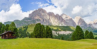
The Odles Group (Geislergruppe or Geislerspitzen in German) is a mountain range in the Dolomites that, together with the Puez Group, constitutes the majority of the territory of the Puez-Odles Nature Park, bordered by the Val Badia, Val Gardena, and Val di Funes, in South Tyrol.
Geography

The highest peaks in the chain are Sass Rigais and Furchetta, both at 3,025 meters.
At the base of the Odle di Funes, one can follow the so-called “Odles Trail” (in German Adolf Munkel-Weg), which passes at the northern base of the Odles Group, where there is also a rock climbing gym.
Toponym

The name is attested in 1759 as Gaislerspitz and in 1770 as Geisler Spiz.[1]
The term Odles translates from the Ladin language simply as “needles” referring to the pointed shape of many peaks in this group.
Classification

According to the SOIUSA, the Odle are an Alpine group with the following classification:
Subdivision
The SOIUSA divides the Odle Group into two subgroups[2]:
- Odles Group proper (a)
- Raschiesa Subgroup (b)
Main Peaks

- Sass Rigais, 3,025 m
- Furchetta, 3,025 m
- Sass de Porta (Seekofel), 2,915 m
- Sass da l’Ega (Wasserkofel), 2,915 m
- Gran Fermeda (Fermeda), 2,873 m
- Gran Odla (Feislerspitz), 2,832 m
- Sass de Mesdì (Mittagsspitz), 2,760 m
- Mount Tullen (Tullen), 2,654 m
- Alpe Raschiesa di Fuori (Außerraschötzer Alm), 2,284 m
Notes
- ^ Egon Kühebacher, Die Ortsnamen Südtirols und ihre Geschichte, vol. 3, Bolzano, Athesia, 2000, p. 79. ISBN 88-8266-018-4
- ^ In parentheses, the SOIUSA code of the two subgroups is reported.
Bibliography
- Marazzi, Sergio (2005). Atlante Orografico delle Alpi. SOIUSA. Pavone Canavese: Priuli & Verlucca. ISBN 978-88-8068-273-8.
External Links

