


Content deleted Content added
|
|
|||
| Line 139: | Line 139: | ||
|
}} |
}} |
||
|
In the 2023 census, 4,079 (0.8%) people in the district were from religious minorities, mainly Christians.<ref name=”2023table9″>{{cite web |title=7th Population and Housing Census – Detailed Results: Table 9 |url=https://www.pbs.gov.pk/sites/default/files/population/2023/tables/balochistan/dcr/table_9.pdf |website=[[Pakistan Bureau of Statistics]]}}</ref> |
In the 2023 census, 4,079 (0.8%) people in the district were from religious minorities, mainly Christians.<ref name=”2023table9″>{{cite web |title=7th Population and Housing Census – Detailed Results: Table 9 |url=https://www.pbs.gov.pk/sites/default/files/population/2023/tables/balochistan/dcr/table_9.pdf |website=[[Pakistan Bureau of Statistics]]}}</ref> |
||
|
=== Language === |
=== Language === |
||
Latest revision as of 02:27, 29 October 2025
District in Balochistan, Pakistan
District of Balochistan in Pakistan

Panjgur (Balochi: پنجگور دمگ, Urdu: ضلع پنجگور) is a district in the western part of Balochistan province of Pakistan. Panjgur was one of three tehsils of Makran District until 1 July 1977, when the district became a part of Makran Division. The other two districts of Makran Division are Kech (Turbat) and Gwadar. Chitkan is the district headquarter. Panjgur has sixteen (16) Union Councils.
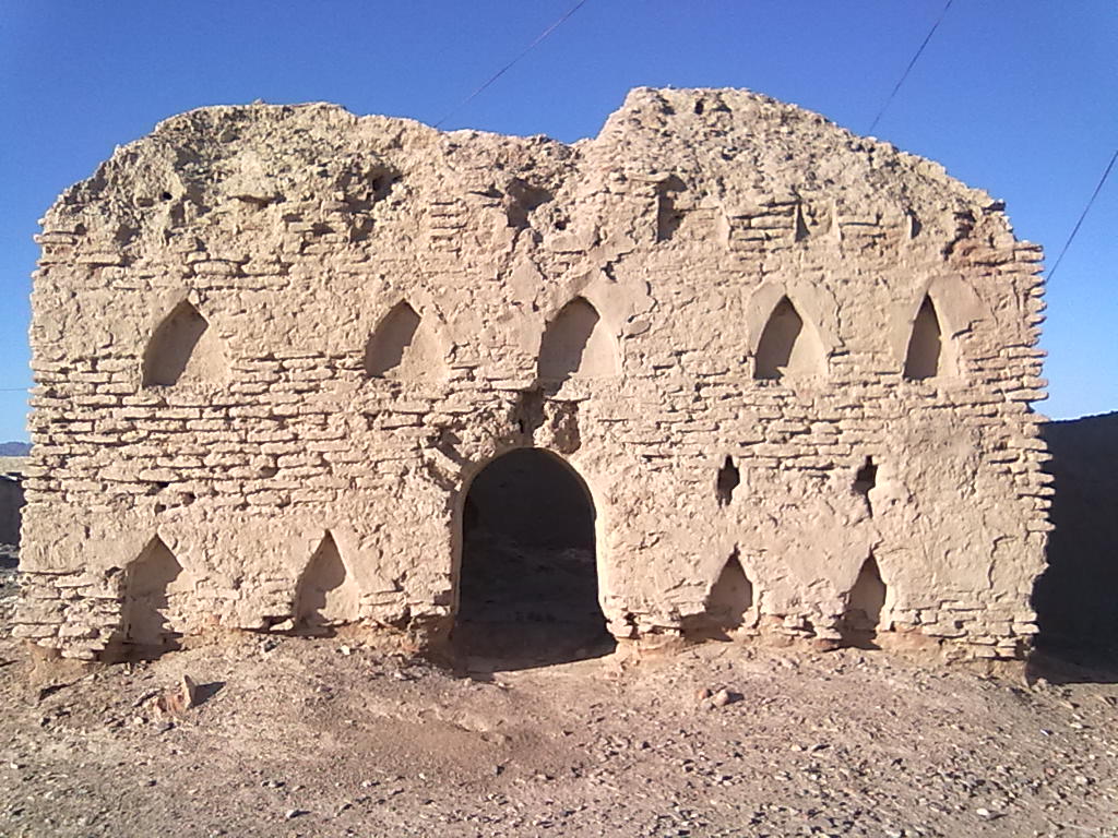
Panjgur (literally: Five Graves) is home to several archaeological sites, including centuries-old tombs, an old dam called Band-e-Gillar, remnants of a fort at Khudabadan (the historical fort of Nawab Kharan) and some remnants of the old port of Issai. The seasonal Rakshan River flows right in the middle of Panjgur, dividing it into two parts, the northern and southern Panjgur.
In Iranian languages, “panj” means “five” and “gor” means “graves”. There are five popular graves in this district, which give it the name Panjgur or Panjgor.[citation needed]
Administrative divisions
[edit]
The district is administratively subdivided into the following tehsils which contain a total of 16 Union Councils:[3]
| Year | ||
|---|---|---|
| 1951 | 29,560 | — |
| 1961 | 27,228 | −0.82% |
| 1972 | 56,820 | +6.92% |
| 1981 | 160,750 | +12.25% |
| 1998 | 234,051 | +2.23% |
| 2017 | 315,353 | +1.58% |
| 2023 | 509,781 | +8.33% |
| Sources:[6] | ||
As of the 2023 census, Panjgur district has 117,089 households and a population of 509,781. The district has a sex ratio of 112.09 males to 100 females and a literacy rate of 42.07%: 45.80% for males and 37.80% for females.[7][8] 155,552 (30.51% of the surveyed population) are under 10 years of age.[9] 157,693 (30.93%) live in urban areas.[7]
In the 2023 census, 4,079 (0.8%) people in the district were from religious minorities, mainly Christians.[10]
Balochi was the predominant language, spoken by 99.63% of the population.[1]
Panjgur Airport (IATA: PJG, ICAO: OPPG) is a domestic airport. Its short runway stretches only 1,524 meters. PIA started flights to Sharjah in 2013, but these have been suspended by PIA.[citation needed] People in Panjgur normally travel by buses to bigger cities like Quetta and Karachi.[citation needed]
- ^ a b “Population by Mother Tongue, Sex and Rural/Urban, Census-2023” (PDF). Pakistan Bureau of Statistics.
- ^ “Literacy rate, enrolments, and out-of-school population by sex and rural/urban, CENSUS-2023, BALOCHISTAN” (PDF).
- ^ a b c d “Tehsils & Unions in the District of Panjgur – Government of Pakistan website”. Archived from the original on 26 March 2012. Retrieved 16 April 2023.
- ^ “TABLE 1 : AREA, POPULATION BY SEX, SEX RATIO, POPULATION DENSITY, URBAN POPULATION, HOUSEHOLD SIZE AND ANNUAL GROWTH RATE, CENSUS-2023, BALOCHISTAN” (PDF).
- ^ “LITERACY RATE, ENROLMENT AND OUT OF SCHOOL POPULATION BY SEX AND RURAL/URBAN, CENSUS-2023, BALOCHISTAN” (PDF).
- ^ “Population by administrative units 1951-1998” (PDF). Pakistan Bureau of Statistics.
- ^ a b “7th Population and Housing Census – Detailed Results: Table 1” (PDF). Pakistan Bureau of Statistics.
- ^ “7th Population and Housing Census – Detailed Results: Table 12” (PDF). Pakistan Bureau of Statistics.
- ^ “7th Population and Housing Census: Population by Mother Tongue, Sex and Rural/Urban” (PDF). Pakistan Bureau of Statistics.
- ^ a b “7th Population and Housing Census – Detailed Results: Table 9” (PDF). Pakistan Bureau of Statistics.


