


Content deleted Content added
|
Tags: Mobile edit Mobile web edit
|
|||
| Line 4: | Line 4: | ||
|
| native_name = |
| native_name = |
||
|
| image = Wooden_bridge_connect_Ebini_to_Akpanta.jpg |
| image = Wooden_bridge_connect_Ebini_to_Akpanta.jpg |
||
|
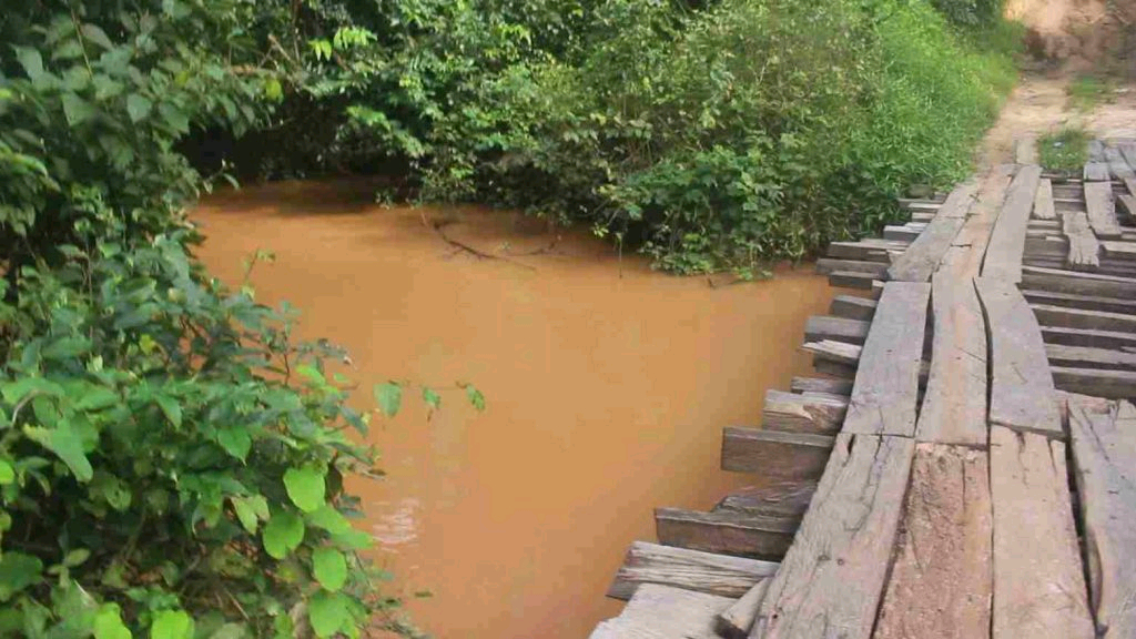
| image_caption = Local wooden bridge across River Ochekwu, linking Ebini and Akpanta communities, Benue State |
| image_caption = Local wooden bridge across River Ochekwu, linking Ebini and Akpanta communities, Benue State |
||
|
| image_alt = Wooden bridge over River Ochekwu |
| image_alt = Wooden bridge over River Ochekwu |
||
|
| pushpin_map = Nigeria |
| pushpin_map = Nigeria |
||
| Line 11: | Line 11: | ||
|
| subdivision_name1 = {{flagicon|Nigeria}} Nigeria |
| subdivision_name1 = {{flagicon|Nigeria}} Nigeria |
||
|
| subdivision_type2 = State |
| subdivision_type2 = State |
||
|
| subdivision_name2 = Benue State |
| subdivision_name2 = Benue State |
||
|
| subdivision_type3 = Local government areas |
| subdivision_type3 = Local government areas |
||
|
| subdivision_name3 = Apa; Agatu |
| subdivision_name3 = Apa; Agatu |
||
|
| length = <!– not publicly verified –> |
| length = <!– not publicly verified –> |
||
|
| source1_location = Upland catchments near the |
| source1_location = Upland catchments near the boundary (reported) |
||
|
| source1_country = Nigeria |
| source1_country = Nigeria |
||
|
| mouth = |
| mouth = River (via local tributary network) |
||
|
| mouth_location = Benue |
| mouth_location = Benue basin |
||
|
| coordinates = {{coord|7.6031|7.8867|display=title|region:NG-BE_type:river}} |
| coordinates = {{coord|7.6031|7.8867|display=title|region:NG-BE_type:river}} |
||
|
}} |
}} |
||
Revision as of 00:59, 7 November 2025
River in Benue State, Nigeria
| River Ochekwu | |
|---|---|
 Local wooden bridge across River Ochekwu, linking Ebini and Akpanta communities, Benue State
|
|
| Country | |
| State | Benue State |
| Local government areas | Apa; Agatu |
| Source | |
| • location | Upland catchments near the Kogi–Benue boundary (reported) |
| Mouth | River Benue (via local tributary network) |
|
• location |
River Benue basin |

River Ochekwu is a freshwater river and seasonal watercourse in North-Central Nigeria. It flows through parts of Apa Local Government Area of Benue State (Ugbokpo, Nigeria and surrounding communities) and is reported in regional studies and local accounts as part of the River Benue drainage network. The river is used locally for domestic water supply, artisanal fishing and small-scale irrigation, and is a geographic reference in reporting on infrastructure and security incidents in Apa and Agatu local government areas. [1][2]
Geography
River Ochekwu is described in local and scientific sources as running through the southern sector of Apa LGA and joining local tributary channels in Agatu LGA en route to the Benue River. Field reports and local mapping used in regional studies identify Ochekwu in proximity to Ugbokpo, Nigeria, Akpanta, Nigeria, Odejo and other settlements in Apa and Agatu. [3][4]
Hydrology and ecology
Targeted limnological work has sampled River Ochekwu directly; such surveys report plankton populations and baseline physicochemical parameters consistent with small lowland tropical tributaries in the Upper Benue watershed. Regional hydrological analyses of the Upper Benue underscore the role of minor tributaries — including Ochekwu — in seasonal discharge, sediment transport and local water availability. [2][5]
Socio-economic importance
Communities along River Ochekwu depend on the river for fishing, household water and farm irrigation. State and local planning documents cite the Ochekwu/Okpokwu stream network as an important resource for Apa LGA’s settlements and infrastructure planning. A locally-important bridge over River Ochekwu in Ugbokpo Ward connecting Ugbokpo to Ijaha, Akpanta, Ikobi and Odejo communities was reported destroyed in March 2024 during an attack by suspected Islamic Fulani militia (herders), demonstrating the river’s significance for transport and market access. [6][7]
Research and data availability
Several scientific and technical reports explicitly include River Ochekwu as a sampling location or geographic feature; however, a single comprehensive public GIS polyline mapping the river’s full course is not currently available in the open record. Researchers should consult state survey maps (Ministry of Lands & Survey), peer-reviewed limnological studies and NIHSA hydrological datasets for primary data on channel geometry, flow regimes and water quality. [3][2][8]


