


From Wikipedia, the free encyclopedia
Content deleted Content added
|
|
|||
| Line 78: | Line 78: | ||
|
=== Sources === |
=== Sources === |
||
|
*{{cite journal |last1=Evans |first1=David J.A. |last2=Young |first2=Brian |title=The abnormally large “hushes” of Teesdale, North Pennines, England: Differentiating mining legacy and natural landforms in glaciated Carboniferous bedrock terrain |journal=Proceedings of the Geologists’ Association |date=December 2022 |volume=133 |issue=6 |doi=10.1016/j.pgeola.2022.05.002}} |
*{{cite journal |last1=Evans |first1=David J.A. |last2=Young |first2=Brian |title=The abnormally large “hushes” of Teesdale, North Pennines, England: Differentiating mining legacy and natural landforms in glaciated Carboniferous bedrock terrain |journal=Proceedings of the Geologists’ Association |date=December 2022 |volume=133 |issue=6 |doi=10.1016/j.pgeola.2022.05.002}} |
||
|
== External links == |
|||
|
*[https://webapps.bgs.ac.uk/Memoirs/docs/B01796.html] |
|||
|
{{commons category|Coldberry Gutter}} |
{{commons category|Coldberry Gutter}} |
||
Latest revision as of 14:02, 2 February 2026
|
Coldberry Gutter |
|
|---|---|
 Coldberry Gutter |
|
| • Length | 1 kilometre (0.62 mi) |
| • Width | 50 metres (160 ft) |
| • Depth | 30 metres (98 ft) |
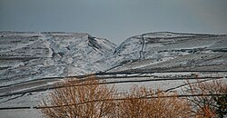
Coldberry Gutter is a narrow incised valley on the watershed between Newbiggin Beck and Hudeshope. The site is known to have been scoured out by hushing for lead, however, modern-day evidence points to the gutter being a glacial meltwater channel, which was utilised by the miners. The Coldberry Gutter is thought to be the largest and most dramatic hush in the North Pennines.
Lead mining was carried on Hardberry Hill on the watershed between the Newbiggin and Hudeshope valleys from the 19th century until c. 1955, though some waste has been reclaimed for possible re-use after mining ceased.[1] The gutter is considered to be the most dramatic of all of the hushes in the Northern Pennines,[2] as its incised V-shape in the hill is visible from the top of Tees High Force.[3] An estimated 825,000 cubic metres (29,100,000 cu ft) of rock removed during mining activity. Whilst it was believed that the gutter was entirely created by mining activity, recent research indicates that the gully might be a natural feature that was utilised by the miners, and thus made wider and deeper than it was originally.[5] Many of the features of the gutter are not those associated with a traditional hush, leading to speculation that the gully is actually a meltwater channel. Coldberry Gutter has been described as a “conspicuous E-W orientated channel-like feature (gorge)”, which is over 1-kilometre (0.62 mi) long, 30 metres (98 ft) deep and 50 metres (160 ft) wide.[2]
The largest reservoir built for the hushing, Hardberry Hill Pool (also known as Coldberry Moss Reservoir), is at 523 metres (1,716 ft) above sea level, with an average depth of 4.7 metres (15 ft), a capacity of 50,927 cubic metres (1,798,500 cu ft), and covering an area of 8,580 square metres (92,400 sq ft).[8] Leats were dug into the hillsides to bring water into the dames and reservoirs, with water from Hardberry Hill Pool being released westwards into the Red Grooves mining complex. The entire site including buildings, walls, dams, earthen banks and the gutter itself, were listed collectively as a scheduled monument in July 1997.[2]
- Evans, David J.A.; Young, Brian (December 2022). “The abnormally large “hushes” of Teesdale, North Pennines, England: Differentiating mining legacy and natural landforms in glaciated Carboniferous bedrock terrain”. Proceedings of the Geologists’ Association. 133 (6). doi:10.1016/j.pgeola.2022.05.002.


