
From Wikipedia, the free encyclopedia
Content deleted Content added
| Line 86: | Line 86: | ||
|
The name ”Chellow” is mentioned in the [[Domesday Book]] as ”celeslau”, and it derives from a person’s name in [[Old English]] “Ceol”, and means ”Ceol’s hill (or) mound”.<ref>{{cite book |last1=Smith |first1=A. H |title=The Place-Names of the West Riding of Yorkshire: Part III: Morley Wapentake |date=1961 |publisher=Cambridge University Press |location=Cambridge |page=244|oclc=1238451143}}</ref><ref>{{cite web |title=Chellow :: Survey of English Place-Names |url=http://epns.nottingham.ac.uk/browse/West+Riding+of+Yorkshire/Bradford/532881dfb47fc40c81000ecd-Chellow |website=epns.nottingham.ac.uk |access-date=2 January 2022}}</ref> At the time of the Domesday survey the area had eight ploughlands and belonged to Ilbert of Lacy.<ref>{{cite web |title=Chellow [Grange] {{!}} Domesday Book |url=https://opendomesday.org/place/SE1235/chellow-grange/ |website=opendomesday.org |access-date=7 February 2026}}</ref> Other subsequent area names include ”Chellow Heights” (where the water treatment works are located),<ref>{{cite web |title=Chellow Heights :: Survey of English Place-Names |url=http://epns.nottingham.ac.uk/browse/id/532881dfb47fc40c81000f03-Chellow+Heights |website=epns.nottingham.ac.uk |access-date=2 January 2022}}</ref> and ”Chellow Dean”, the name of the valley in which the woods, reservoir and the beck are located in.<ref>{{cite web |title=Chellow Dean :: Survey of English Place-Names |url=http://epns.nottingham.ac.uk/browse/id/532881dfb47fc40c81000f01-Chellow+Dean |website=epns.nottingham.ac.uk |access-date=2 January 2022}}</ref> Two spellings of Chellow Dean persist; Dean and Dene. William Cudworth spells the small vale both ways; in 1876, he lists it as ”Chellow Dene” and twenty years later as ”Chellow Dean”.<ref>{{cite book |last1=Cudworth |first1=William |title=Round about Bradford : a series of sketches |date=1876 |publisher=T Brear |location=Bradford |page=167|oclc=1250062187}}</ref> The area of Chellow Dean is first mentioned around the time of Edward III ({{circa|1360}}), where it was described as being “..a certain common pasture for all the tenants of the lord of Bradefordale.”{{#tag:ref|Bradefordale is the old name for the [[Bradford Dale (Yorkshire)|area]], before the various villages became the City of Bradford.|name=Bradforddale|group=note}}{{sfn|Robertshaw|1952|p=8}} |
The name ”Chellow” is mentioned in the [[Domesday Book]] as ”celeslau”, and it derives from a person’s name in [[Old English]] “Ceol”, and means ”Ceol’s hill (or) mound”.<ref>{{cite book |last1=Smith |first1=A. H |title=The Place-Names of the West Riding of Yorkshire: Part III: Morley Wapentake |date=1961 |publisher=Cambridge University Press |location=Cambridge |page=244|oclc=1238451143}}</ref><ref>{{cite web |title=Chellow :: Survey of English Place-Names |url=http://epns.nottingham.ac.uk/browse/West+Riding+of+Yorkshire/Bradford/532881dfb47fc40c81000ecd-Chellow |website=epns.nottingham.ac.uk |access-date=2 January 2022}}</ref> At the time of the Domesday survey the area had eight ploughlands and belonged to Ilbert of Lacy.<ref>{{cite web |title=Chellow [Grange] {{!}} Domesday Book |url=https://opendomesday.org/place/SE1235/chellow-grange/ |website=opendomesday.org |access-date=7 February 2026}}</ref> Other subsequent area names include ”Chellow Heights” (where the water treatment works are located),<ref>{{cite web |title=Chellow Heights :: Survey of English Place-Names |url=http://epns.nottingham.ac.uk/browse/id/532881dfb47fc40c81000f03-Chellow+Heights |website=epns.nottingham.ac.uk |access-date=2 January 2022}}</ref> and ”Chellow Dean”, the name of the valley in which the woods, reservoir and the beck are located in.<ref>{{cite web |title=Chellow Dean :: Survey of English Place-Names |url=http://epns.nottingham.ac.uk/browse/id/532881dfb47fc40c81000f01-Chellow+Dean |website=epns.nottingham.ac.uk |access-date=2 January 2022}}</ref> Two spellings of Chellow Dean persist; Dean and Dene. William Cudworth spells the small vale both ways; in 1876, he lists it as ”Chellow Dene” and twenty years later as ”Chellow Dean”.<ref>{{cite book |last1=Cudworth |first1=William |title=Round about Bradford : a series of sketches |date=1876 |publisher=T Brear |location=Bradford |page=167|oclc=1250062187}}</ref> The area of Chellow Dean is first mentioned around the time of Edward III ({{circa|1360}}), where it was described as being “..a certain common pasture for all the tenants of the lord of Bradefordale.”{{#tag:ref|Bradefordale is the old name for the [[Bradford Dale (Yorkshire)|area]], before the various villages became the City of Bradford.|name=Bradforddale|group=note}}{{sfn|Robertshaw|1952|p=8}} |
||
|
Although today part of [[Allerton, West Yorkshire|Allerton]], Chellow, or Chellow Heights, was its own hamlet in the Township of Heaton.<ref>{{cite web |title=Genuki: In 1822, the following places were in the Parish of Bradford:, Yorkshire (West Riding) |url=https://www.genuki.org.uk/big/eng/YKS/WRY/Bradford/more |website=www.genuki.org.uk |access-date=3 January 2022}}</ref><ref>{{cite web |title=Chellow, West Riding |url=https://www.visionofbritain.org.uk/place/26614/units |website=visionofbritain.org.uk |access-date=3 January 2022}}</ref> |
Although today part of [[Allerton, West Yorkshire|Allerton]], Chellow, or Chellow Heights, was its own hamlet in the Township of Heaton.<ref>{{cite web |title=Genuki: In 1822, the following places were in the Parish of Bradford:, Yorkshire (West Riding) |url=https://www.genuki.org.uk/big/eng/YKS/WRY/Bradford/more |website=www.genuki.org.uk |access-date=3 January 2022}}</ref><ref>{{cite web |title=Chellow, West Riding |url=https://www.visionofbritain.org.uk/place/26614/units |website=visionofbritain.org.uk |access-date=3 January 2022}}</ref> |
||
|
Flagstones were quarried in the area just to the north of Chellow Heights reservoir. |
Flagstones were quarried in the area just to the north of Chellow Heights reservoir. |
||
Revision as of 12:17, 11 February 2026
| Chellow Dene | |
|---|---|
.jpg)
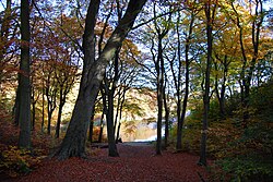
Chellow Dean woods and upper reservoir |
History
The name Chellow is mentioned in the Domesday Book as celeslau, and it derives from a person’s name in Old English “Ceol”, and means Ceol’s hill (or) mound.[1][2] At the time of the Domesday survey the area had eight ploughlands and belonged to Ilbert of Lacy.[3] Other subsequent area names include Chellow Heights (where the water treatment works are located),[4] and Chellow Dean, the name of the valley in which the woods, reservoir and the beck are located in.[5] Two spellings of Chellow Dean persist; Dean and Dene. William Cudworth spells the small vale both ways; in 1876, he lists it as Chellow Dene and twenty years later as Chellow Dean.[6] The area of Chellow Dean is first mentioned around the time of Edward III (c. 1360), where it was described as being “..a certain common pasture for all the tenants of the lord of Bradefordale.”[note 1]
Although today part of Allerton, Chellow, or Chellow Heights, was its own hamlet in the Township of Heaton, and the township of Heaton was incorporated within Bradford in 1882.[8][9]
Flagstones were quarried in the area just to the north of Chellow Heights reservoir.
Water treatment works
The waterworks at Chellow Heights were built so that water from the Nidd Aqueduct could then be supplied to most of the Bradford without the need for an expensive pumping station, it being located at 842 feet (257 m) above sea level.[10] The land at Chellow for use by the Bradford Waterworks Corporation was given to the company in 1895 by the Hodgson family. Water from the reservoirs in the upper Nidd Valley takes approximately 18 hours to arrive at Chellow Heights, which is restricted to the amount of water it can abstract per day, (this was 113,000,000 cubic metres (4.0×10⁹ cu ft) per day in 2006).[12]
Reservoirs
The two reservoirs at Chellow Dean were built in 1844 and 1850, when water was piped from a source at Manywells Spring near Hewenden Reservoir at Cullingworth. The upper reservoir lies at a height of 211 metres (692 ft) above sea level, and contains around 115,080 cubic metres (4,064,000 cu ft) of water.[13] the second reservoir, just to the east and 20 metres (66 ft) lower at 191 metres (627 ft) above sea level, holds around 70,550 cubic metres (2,491,000 cu ft) of water.[14] Water exits these reservoirs through Chellow Dene Beck, which in 2005, was converted into a wetland area to filter the water as it left towards Bradford Beck. The wetlands were renovated in 2024 as the filter beds had silted up and stopped cleaning the water water and acting as a floodplain in times of high rainfall.[15][16]
Notes
References
Sources
- Bowtell, Harold D. (1991). Lesser railways of the Yorkshire Dales : and the dam builders in the Age of Steam. Brighton: Plateway Press. ISBN 1-871980-09-7.
- Robertshaw, Wilfrid (1952). “The Manor of Chellow”. The Bradford Antiquary. 7. Bradford: The Bradford Historical and Antiquarian Society. ISSN 0955-2553.
External links

