
Content deleted Content added
|
|
|||
| Line 62: | Line 62: | ||
|
| North = Forcella Larga |
| North = Forcella Larga |
||
|
| Northeast = Torrente Pramper |
| Northeast = Torrente Pramper |
||
|
| East = Cima di Pramper |
| East = Cima di Pramper |
||
|
| Southeast = Moschesin Pass |
| Southeast = Moschesin Pass |
||
|
| South = [[Belluno]] |
| South = [[Belluno]] |
||
Latest revision as of 09:33, 14 December 2025
Mountain in Italy
Castello di Moschesin is a mountain in the province of Belluno of northern Italy.
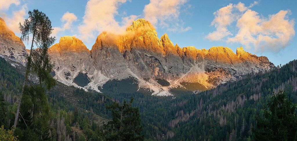
Castello di Moschesin, labeled as Monte Castello on the official IGM map,[3] is a 2,499-meter-elevation (8,199-foot) summit in the Dolomites in the Veneto region. The peak is located seven kilometers (4.35 miles) east-northeast of the town of Agordo, and the peak is the sixth-highest in Dolomiti Bellunesi National Park,[1] a UNESCO World Heritage Site. Precipitation runoff from the mountain’s slopes drains into tributaries of the Piave. Topographic relief is significant as the summit rises 950 meters (3,117 feet) along the east slope in approximately one kilometer (0.6 mile), and 1,150 meters (3,773 feet) along the west slope in two kilometers (1.24 miles). The nearest higher neighbor is Tamer Grande, 1.6 kilometer (1 mile) to the northwest.[1] The mountain is named in association with Forcella Moschesin (Moschesin Pass) adjacent to the south, and the first known ascent of the summit was made in 1885 by IGM topographers.[4]
Based on the Köppen climate classification, Castello di Moschesin is located in an alpine climate zone with long, cold winters, and short, mild summers.[5] Weather systems are forced upwards by the mountains (orographic lift), causing moisture to drop in the form of rain and snow. The months of June through September offer the most favorable weather for visiting or climbing in this area.[6]
- ^ a b c d e f g “Castello Di Moschesin”. peakvisor.com. Retrieved October 23, 2025.
- ^ Montagna per tutti, Pietro Baroni, Touring Editore, 2004, ISBN 9788836530571, p. 229.
- ^ “Monte Castello, Italy”. Peakbagger.com. Retrieved October 23, 2025.
- ^ Moschesin Castle (2499 m), normal ascent route, Luca Bridda, October 11, 2015, abcdolomiti.com, Retrieved October 23, 2025.
- ^ Peel, M.C.; Finlayson, B.L. & McMahon, T.A. (2007). “Updated world map of the Köppen-Geiger climate classification” (PDF). Hydrology and Earth System Sciences. 11 (5): 1633–1644. Bibcode:2007HESS…11.1633P. doi:10.5194/hess-11-1633-2007. Archived (PDF) from the original on 2019-12-02. Retrieved 2025-11-07.
- ^ Best Time to Visit the Dolomites (+ Months to Avoid), Moonhoneytravel.com, Retrieved October 22, 2025.

