Borough
Inner
Status
Local authority
Political control
Headquarters
Area
Population
Location
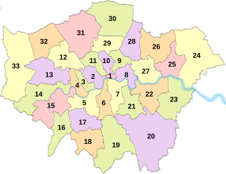
Map ref.
Barking and Dagenham [ note 1]
Barking and Dagenham London Borough Council
Labour
Town Hall , 1 Town Square
13.93 sq mi (36.1 km2 )
219,992
51°33′39″N 0°09′21″E / 51.5607°N 0.1557°E / 51.5607; 0.1557 (Barking and Dagenham ) 25
Barnet
Barnet London Borough Council
Labour
2 Bristol Avenue , Colindale
33.49 sq mi (86.7 km2 )
389,101
51°37′31″N 0°09′06″W / 51.6252°N 0.1517°W / 51.6252; -0.1517 (Barnet ) 31
Bexley
Bexley London Borough Council
Conservative
Civic Offices , 2 Watling Street
23.38 sq mi (60.6 km2 )
247,835
51°27′18″N 0°09′02″E / 51.4549°N 0.1505°E / 51.4549; 0.1505 (Bexley ) 23
Brent
Brent London Borough Council
Labour
Brent Civic Centre , Engineers Way
16.70 sq mi (43.3 km2 )
341,221
51°33′32″N 0°16′54″W / 51.5588°N 0.2817°W / 51.5588; -0.2817 (Brent ) 12
Bromley
Bromley London Borough Council
Conservative
Civic Centre , Churchill Court
57.97 sq mi (150.1 km2 )
329,578
51°23′57″N 0°00′59″E / 51.3992°N 0.0165°E / 51.3992; 0.0165 (Bromley ) 20
Camden
Yes
Camden London Borough Council
Labour
5 Pancras Square
8.40 sq mi (21.8 km2 )
218,049
51°31′44″N 0°07′32″W / 51.5290°N 0.1255°W / 51.5290; -0.1255 (Camden ) 11
Croydon
Croydon London Borough Council
No overall control
Bernard Weatherill House , Mint Walk
33.41 sq mi (86.5 km2 )
392,224
51°22′17″N 0°05′52″W / 51.3714°N 0.0977°W / 51.3714; -0.0977 (Croydon ) 19
Ealing
Ealing London Borough Council
Labour
Perceval House , 14-16 Uxbridge Road
21.44 sq mi (55.5 km2 )
369,937
51°30′47″N 0°18′32″W / 51.5130°N 0.3089°W / 51.5130; -0.3089 (Ealing ) 13
Enfield
Enfield London Borough Council
Labour
Civic Centre , Silver Street
31.74 sq mi (82.2 km2 )
327,224
51°39′14″N 0°04′48″W / 51.6538°N 0.0799°W / 51.6538; -0.0799 (Enfield ) 30
Greenwich [ note 2] Yes [ note 3]
Royal
Greenwich London Borough Council
Labour
Woolwich Town Hall , Wellington Street
18.28 sq mi (47.3 km2 )
291,080
51°29′21″N 0°03′53″E / 51.4892°N 0.0648°E / 51.4892; 0.0648 (Greenwich ) 22
Hackney
Yes
Hackney London Borough Council
Labour
Hackney Town Hall , Mare Street
7.36 sq mi (19.1 km2 )
261,491
51°32′42″N 0°03′19″W / 51.5450°N 0.0553°W / 51.5450; -0.0553 (Hackney ) 9
Hammersmith and Fulham [ note 4] Yes
Hammersmith and Fulham London Borough Council
Labour
Town Hall , King Street
6.33 sq mi (16.4 km2 )
185,238
51°29′34″N 0°14′02″W / 51.4927°N 0.2339°W / 51.4927; -0.2339 (Hammersmith and Fulham ) 4
Haringey
[ note 3]
Haringey London Borough Council
Labour
Civic Centre , High Road
11.42 sq mi (29.6 km2 )
261,811
51°36′00″N 0°06′43″W / 51.6000°N 0.1119°W / 51.6000; -0.1119 (Haringey ) 29
Harrow
Harrow London Borough Council
Conservative
Civic Centre , Station Road
19.49 sq mi (50.5 km2 )
261,185
51°35′23″N 0°20′05″W / 51.5898°N 0.3346°W / 51.5898; -0.3346 (Harrow ) 32
Havering
Havering London Borough Council
No overall control
Town Hall , Main Road
43.35 sq mi (112.3 km2 )
264,703
51°34′52″N 0°11′01″E / 51.5812°N 0.1837°E / 51.5812; 0.1837 (Havering ) 24
Hillingdon
Hillingdon London Borough Council
Conservative
Civic Centre , High Street
44.67 sq mi (115.7 km2 )
310,681
51°32′39″N 0°28′34″W / 51.5441°N 0.4760°W / 51.5441; -0.4760 (Hillingdon ) 33
Hounslow
Hounslow London Borough Council
Labour
Hounslow House , 7 Bath Road
21.61 sq mi (56.0 km2 )
290,488
51°28′29″N 0°22′05″W / 51.4746°N 0.3680°W / 51.4746; -0.3680 (Hounslow ) 14
Islington
Yes
Islington London Borough Council
Labour
Customer Centre , 222 Upper Street
5.74 sq mi (14.9 km2 )
220,373
51°32′30″N 0°06′08″W / 51.5416°N 0.1022°W / 51.5416; -0.1022 (Islington ) 10
Kensington and Chelsea
Yes
Royal
Kensington and Chelsea London Borough Council
Conservative
The Town Hall , Hornton Street
4.68 sq mi (12.1 km2 )
146,154
51°30′07″N 0°11′41″W / 51.5020°N 0.1947°W / 51.5020; -0.1947 (Kensington and Chelsea ) 3
Kingston upon Thames
Royal
Kingston upon Thames London Borough Council
Liberal Democrat
Guildhall , High Street
14.38 sq mi (37.2 km2 )
168,302
51°24′31″N 0°18′23″W / 51.4085°N 0.3064°W / 51.4085; -0.3064 (Kingston upon Thames ) 16
Lambeth
Yes
Lambeth London Borough Council
Labour
Lambeth Town Hall , Brixton Hill
10.36 sq mi (26.8 km2 )
316,812
51°27′39″N 0°06′59″W / 51.4607°N 0.1163°W / 51.4607; -0.1163 (Lambeth ) 6
Lewisham
Yes
Lewisham London Borough Council
Labour
Town Hall , 1 Catford Road
13.57 sq mi (35.1 km2 )
298,653
51°26′43″N 0°01′15″W / 51.4452°N 0.0209°W / 51.4452; -0.0209 (Lewisham ) 21
Merton
Merton London Borough Council
Labour
Civic Centre , London Road
14.52 sq mi (37.6 km2 )
210,709
51°24′05″N 0°11′45″W / 51.4014°N 0.1958°W / 51.4014; -0.1958 (Merton ) 17
Newham
[ note 3]
Newham London Borough Council
Labour
Newham Dockside , 1000 Dockside Road
13.98 sq mi (36.2 km2 )
358,645
51°30′28″N 0°02′49″E / 51.5077°N 0.0469°E / 51.5077; 0.0469 (Newham ) 27
Redbridge
Redbridge London Borough Council
Labour
Town Hall , 128-142 High Road
21.78 sq mi (56.4 km2 )
310,911
51°33′32″N 0°04′27″E / 51.5590°N 0.0741°E / 51.5590; 0.0741 (Redbridge ) 26
Richmond upon Thames
Richmond upon Thames London Borough Council
Liberal Democrat
Civic Centre , 44 York Street
22.17 sq mi (57.4 km2 )
194,894
51°26′52″N 0°19′34″W / 51.4479°N 0.3260°W / 51.4479; -0.3260 (Richmond upon Thames ) 15
Southwark
Yes
Southwark London Borough Council
Labour
160 Tooley Street
11.14 sq mi (28.9 km2 )
311,913
51°30′13″N 0°04′49″W / 51.5035°N 0.0804°W / 51.5035; -0.0804 (Southwark ) 7
Sutton
Sutton London Borough Council
Liberal Democrat
Civic Offices , St Nicholas Way
16.93 sq mi (43.8 km2 )
209,602
51°21′42″N 0°11′40″W / 51.3618°N 0.1945°W / 51.3618; -0.1945 (Sutton ) 18
Tower Hamlets
Yes
Tower Hamlets London Borough Council
Independent
Town Hall , Whitechapel Road
7.63 sq mi (19.8 km2 )
325,789
51°30′36″N 0°00′21″W / 51.5099°N 0.0059°W / 51.5099; -0.0059 (Tower Hamlets ) 8
Waltham Forest
Waltham Forest London Borough Council
Labour
Waltham Forest Town Hall , Forest Road
14.99 sq mi (38.8 km2 )
275,887
51°35′27″N 0°00′48″W / 51.5908°N 0.0134°W / 51.5908; -0.0134 (Waltham Forest ) 28
Wandsworth
Yes
Wandsworth London Borough Council
Labour
The Town Hall , Wandsworth High Street
13.23 sq mi (34.3 km2 )
329,035
51°27′24″N 0°11′28″W / 51.4567°N 0.1910°W / 51.4567; -0.1910 (Wandsworth ) 5
Westminster
Yes
City
Westminster City Council
Labour
Westminster City Hall , 64 Victoria Street
8.29 sq mi (21.5 km2 )
211,365
51°29′50″N 0°08′14″W / 51.4973°N 0.1372°W / 51.4973; -0.1372 (Westminster ) 2