


== Recreation ==
== Recreation ==
[[File:Paul Bunyan State Trail, Minnesota (29695730308).jpg|thumb|312x312px|A sign for the Paul Bunyan State Trail in Pine River, Crow Wing County, Minnesota.]]
==== Water Sports and Boating ====
<ref>{{Cite web |title=Clark Lake Minnesota Lake Homes For Sale and Clark Lake Minnesota Lake Houses For Sale – LakeHomes.com |url=https://www.lakehomes.com/minnesota/offmarket/clark-lake |access-date=2025-12-21 |website=Lake Homes Realty |language=en-US}}</ref><ref>{{Cite web |title=Lakes – Chad Schwendeman Real Estate group brokered by eXp Realty |url=https://chadsrg.com/lakes.php |access-date=2025-12-21 |website=chadsrg.com}}</ref>[[File:Paul Bunyan State Trail, Minnesota (29695730308).jpg|thumb|312x312px|A sign for the Paul Bunyan State Trail in Pine River, Crow Wing County, Minnesota.]]
==== Nearby Trails and Parks ====
==== Nearby Trails and Parks ====
Some notable recreation near Clark Lake consists of [[Paul Bunyan State Trail]] <ref>{{Cite web |title=Map of Southern Paul Bunyan State Trail |url=https://files.dnr.state.mn.us/maps/state_trails/paul_bunyan_s.pdf}}</ref>a state trail that is 115 miles long and is the longest continuously paved rail-trail in the country<ref>{{Cite news |title=Paul Bunyan State Trail |url=https://www.dnr.state.mn.us/state_trails/paul_bunyan/index.html |archive-url=http://web.archive.org/web/20251208153927/https://www.dnr.state.mn.us/state_trails/paul_bunyan/index.html |archive-date=2025-12-08 |access-date=2025-12-22 |work=Minnesota Department of Natural Resources |language=en}}</ref>, [[Pillsbury State Forest|Pillsbury state forest]] a state forest since 1935<ref>{{Cite web |title=Pillsbury State Forest Map |url=https://files.dnr.state.mn.us/maps/state_forests/sft00039.pdf}}</ref> and Paul M Thiede Fire Tower Park a historic fire tower built by the [[Civilian Conservation Corps]] in 1935 to help spot [[Wildfire|wildfires]].<ref>{{Cite web |last=Nisswa |first=Camp |date=2025-04-15 |title=Paul M. Thiede Fire Tower Park {{!}} Pequot Lakes, MN |url=https://www.campnisswa.com/post/paul-thiede-fire-tower-park-pequot-lakes-mn |access-date=2025-12-22 |website=Camp Nisswa |language=en}}</ref>
Some notable recreation near Clark Lake consists of [[Paul Bunyan State Trail]] <ref>{{Cite web |title=Map of Southern Paul Bunyan State Trail |url=https://files.dnr.state.mn.us/maps/state_trails/paul_bunyan_s.pdf}}</ref>a state trail that is 115 miles long and is the longest continuously paved rail-trail in the country<ref>{{Cite news |title=Paul Bunyan State Trail |url=https://www.dnr.state.mn.us/state_trails/paul_bunyan/index.html |archive-url=http://web.archive.org/web/20251208153927/https://www.dnr.state.mn.us/state_trails/paul_bunyan/index.html |archive-date=2025-12-08 |access-date=2025-12-22 |work=Minnesota Department of Natural Resources |language=en}}</ref>, [[Pillsbury State Forest|Pillsbury state forest]] a state forest since 1935<ref>{{Cite web |title=Pillsbury State Forest Map |url=https://files.dnr.state.mn.us/maps/state_forests/sft00039.pdf}}</ref> and Paul M Thiede Fire Tower Park a historic fire tower built by the [[Civilian Conservation Corps]] in 1935 to help spot [[Wildfire|wildfires]].<ref>{{Cite web |last=Nisswa |first=Camp |date=2025-04-15 |title=Paul M. Thiede Fire Tower Park {{!}} Pequot Lakes, MN |url=https://www.campnisswa.com/post/paul-thiede-fire-tower-park-pequot-lakes-mn |access-date=2025-12-22 |website=Camp Nisswa |language=en}}</ref>
According to the Minnesota Department of Natural Resources to legally fish in Minnesota, all residents of Minnesota, age 16 to 89, must have a current Minnesota fishing license unless an exemption applies.<ref>{{Cite web |title=Fishing Licenses |url=https://mn.gov/elicense/a-z/?id=1083-231612#/list/appId//filterType//filterValue//page/1/sort//order/ |access-date=2025-12-21 |website=mn.gov |language=en}}</ref>
According to the Minnesota Department of Natural Resources to legally fish in Minnesota, all residents of Minnesota, age 16 to 89, must have a current Minnesota fishing license unless an exemption applies.<ref>{{Cite web |title=Fishing Licenses |url=https://mn.gov/elicense/a-z/?id=1083-231612#/list/appId//filterType//filterValue//page/1/sort//order/ |access-date=2025-12-21 |website=mn.gov |language=en}}</ref>
====== Who doesn’t need a fishing license ======
====== Who doesn’t need a fishing license ======
* Residents younger than 16.
* Residents younger than 16.
Clark Lake, located in Crow Wing County, Minnesota is a Northern Minnesota lake named after Clark L. Thorpe,[4] who was a son of the famous American portrait painter and Ohio Legislator Freeman Thorpe.[5]
Etymology
In 1908 when the village of Nisswa was incorporated, the name was changed to Nisswa from the Ojibwe word nessawae, which translates to “in the middle” in this case in the middle refers to Nisswa being in the middle of Clark, Nisswa, and Roy lakes.[6][7]
Physical characteristics
Location
Clark lake is located in Crow Wing County, MN, 15 miles north of the city of Brainerd and Located in the Brainerd Lakes Area.[8]
Water Features
Hydrology
Basic Lake Characterisitics
Clark lake covers approximately 343 acres, and has a maximum depth of approximately 31 feet[9][10], it also has a Littoral Area of 264 acres, and a average water clarity of 14.8 ft.[11]
Hydrologic setting and water balance
Clark Lake is a type 1 lake in the Glacial Lake Brainerd deposits. It has a relativity large ratio of 42:1. During most years, it received sufficient surface-water input to maintain the water elevation above its runout elevation.[12]
Watershed and regional context
Some major watersheds of Clark lake include the Crow Wing River and Upper Gull lake.[13]
Formation
Minnesota’s lakes are a legacy of the glaciers that used to cover its landscape approximately 10,000 years ago. As these glaciers retreated they left a mark of a wide variety of sunken area’s lower the surrounding land, some of these were shallow, some deep, some carved straight out of the bedrock, and others were surrounded by sand.[14]
Ecology

Fish Species
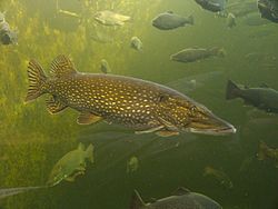
Fish species in the Clark Lake include black bullhead, black crappie, bluegill, brown bullhead, green sunfish, hybrid sunfish, largemouth bass, northern pike, pumpkinseed, smallmouth bass, walleye, yellow bullhead, yellow perch, bowfin (dogfish), common carp, white sucker, banded killifish, blacknose shiner, bluntnose minnow, emerald shiner, and golden shiner.[15][16]
Invasive Species
Clark lake has had one main invasive species, that of which is the Zebra Mussel[17][18], it is listed by the Minnesota Department of Natural Resources for aquatic invasive species in Clark Lake[19], the year it was listed as infested in the lake was in 2017.[20]

History
Thorp Family
In the Clark/Hubert Lakes region the Thorp (often spelled Thorpe) family name is often associated with Freeland Woodcock Thorp and his son Clark L. Thorp whom which Clark Lake in Crow wing County Minnesota is named after. Clark who was born to Orlena Alberton Eggleston who was 22, and his father Freeman Woodcock Thorp at the age of 25 in the US state of Ohio in 1869[21], in 1893 a young Clark became ill and had the second known operation for appendicitis. Later, because of the administration of the anesthetic, he developed pulmonary tuberculosis, His family was told the only hope for Clark was the northern Minnesotan air[22], Clark died in 1896 at the age of 27, he is buried in Thorp-Heald Cemetery and in his memory Clark Lake was named after him.[23][24]
Clark’s Father, Freeland was a well known portrait painter, commander in the Ohio National Guard until 1885, and Ohio State representative[25], moved to Crow Wing County in the 1890s due to ill health where he built “The Castle” a 3000 brick castle that was a icon of Nisswa and stood from 1906-1941 until it was demolished due to deterioration[26], Because of recent efforts to preserve the cemetery where the Thorpe family rests, it led to the discovery of brick remains of the castle[27]. Freeland continued painting until his death in October of 1922 at the age of 78.[28]
Lake Hubert Depot
Lake Hubert Depot was built in 1896 (though other sources say 1918) along the narrow strip of land between Clark lake and Lake Hubert by the Northern Pacific Railway during the logging boom in 1896. and was the only way to reach the Town of Lake Hubert.[29][30]
Lake Hubert Stations significance to the region is being the only known surviving open shed station in north central Minnesota, and as a representative of the early interrelationship between the railroad and the regional resort industry.[31]
Recreation
.jpg)
Nearby Trails and Parks
Some notable recreation near Clark Lake consists of Paul Bunyan State Trail [32]a state trail that is 115 miles long and is the longest continuously paved rail-trail in the country[33], Pillsbury state forest a state forest since 1935[34] and Paul M Thiede Fire Tower Park a historic fire tower built by the Civilian Conservation Corps in 1935 to help spot wildfires.[35]
Conservation and management
Key Organizations
Major Organizations focused on land preservation, water quality, and wildlife specifically in the Brainerd Lakes Region include The Minnesota Department of Natural resources, Minnesota Land Trust, The Northern Waters Land Trust, The Brainerd Lakes Area Audubon Society, The National Wildlife Federation, and the US Fish & Wildlife Service.
Local Guidelines
According to the Minnesota Department of Natural Resources to legally fish in Minnesota, all residents of Minnesota, age 16 to 89, must have a current Minnesota fishing license unless an exemption applies.[36]
Who doesn’t need a fishing license?
- Residents younger than 16.
- Residents 90 and older.
- Minnesota residents enlisted in the U.S. Armed Forces, stationed outside the state, and home on leave(you must carry leave or furlough papers while fishing or transporting fish).
- A Minnesota resident who has served in federal active service outside the U.S. during the preceding 24 months and is now discharged from overseas duty (you must carry discharge papers while fishing or transporting fish).
- An in-patient of a U.S. Veterans Administration hospital (form needed to filled out).
- A resident of a Minnesota licensed nursing or boarding care home.[37]
Climate
| Climate data for Nisswa, Minnesota | |||||||||||||
|---|---|---|---|---|---|---|---|---|---|---|---|---|---|
| Month | Jan | Feb | Mar | Apr | May | Jun | Jul | Aug | Sep | Oct | Nov | Dec | Year |
| Mean daily maximum °F | 18.9 | 24.4 | 37 | 52.0 | 65.1 | 74.7 | 79.2 | 77.4 | 68.5 | 54 | 37.8 | 24.4 | 51.1 |
| Mean daily minimum °F | −0.2 | 2.7 | 16.3 | 30 | 43.5 | 54.1 | 58.6 | 55.8 | 47.1 | 34.9 | 21.9 | 8.8 | 31.1 |
| Average precipitation inches | 0.69 | 0.73 | 1.32 | 2.25 | 3.45 | 4.23 | 4.38 | 3.46 | 2.74 | 3.01 | 1.21 | 0.88 | 28.35 |
| Mean daily maximum °C | −7.3 | −4.2 | 3 | 11.1 | 18.4 | 23.7 | 26.2 | 25.2 | 20.3 | 12 | 3.2 | −4.2 | 10.6 |
| Mean daily minimum °C | −17.9 | −16.3 | −8.7 | −1 | 6.4 | 12.3 | 14.8 | 13.2 | 8.4 | 1.6 | −5.6 | −12.9 | −0.5 |
| Average precipitation mm | 17.53 | 18.54 | 33.53 | 57.15 | 87.63 | 107.44 | 111.25 | 87.88 | 69.6 | 76.45 | 30.73 | 22.35 | 720.08 |
| Source: Plantmaps.com[38] | |||||||||||||
Public Water Access
A ramp for public water access is located on County Road 13, east of Highway 371[39], the ramp’s official name is Clark Lake Public Water Access Site, its launch type is a trailer launch and the ramp type is listed as a concrete slab[40][41]
References
- ^ https://www.lake-link.com/minnesota-lakes/crow-wing-county/clark-lake/7307/
- ^ https://waterdata.usgs.gov/monitoring-location/USGS-05246330/statistics/
- ^ https://www.topozone.com/minnesota/crow-wing-mn/lake/clark-lake-15/
- ^ “Clark L. Thorp (1869-1896) – Find a Grave Memorial”. www.findagrave.com. Retrieved 2025-12-19.
- ^ Beacon, CARL E. FEATHER-cfeather@starbeacon comStar (2011-11-20). “The youth who sketched Lincoln”. Star Beacon. Retrieved 2025-12-22.
- ^ “Welcome to the City of Nisswa”. www.cityofnisswa.gov. Retrieved 2025-12-20.
- ^ “History of Clark Lake”. Issuu. Retrieved 2025-12-20.
- ^ “Clark Lake Minnesota Lake Homes For Sale and Clark Lake Minnesota Lake Houses For Sale – LakeHomes.com”. Lake Homes Realty. Retrieved 2025-12-21.
- ^ “Clark Lake MN Map – Minnesota Lake Resorts – Lake Lodging in MN”. Brainerd.com. Retrieved 2025-12-19.
- ^ background, Pineandlakes Echo Journal Comments Share Share this article Explainer Explainer Provides context or; definition; this?, detail on a specific topic The Trust Project What is (2025-05-19). “Clark Lake contour map – Crow Wing County”. Pine & Lakes Echo Journal. Retrieved 2025-12-19.
- ^ “Clark (18037400) | LakeFinder”. Minnesota Department of Natural Resources. Archived from the original on 2024-10-09. Retrieved 2025-12-19.
- ^ https://files.dnr.state.mn.us/waters/groundwater_section/mapping/cga/c16_crow/pdf_files/plate10.pdf.
- ^ “Minnesota Biological Survey List of Plant Species Observed at Clark Lake” (PDF).
- ^ “Regional Context: Lakes”. Minnesota Department of Natural Resources. Archived from the original on 2024-02-04. Retrieved 2025-12-19.
- ^ “Clark Lake map – Crow Wing County”. Issuu. 2023-04-27. Retrieved 2025-12-19.
- ^ background, Pineandlakes Echo Journal Comments Share Share this article Explainer Explainer Provides context or; definition; this?, detail on a specific topic The Trust Project What is (2025-05-19). “Clark Lake contour map – Crow Wing County”. Pine & Lakes Echo Journal. Retrieved 2025-12-19.
- ^ “Wayback Machine”. www.crowwing.gov. Archived from the original on 2023-06-02. Retrieved 2025-12-19.
- ^ “Clark Lake (MN) – Fishing, Map & Access”. Lake-Link. Retrieved 2025-12-19.
- ^ “https://www.dnr.state.mn.us/lakefind/lake.html?id=18037400”.
- ^ “Wayback Machine”. www.crowwing.gov. Archived from the original on 2023-06-02. Retrieved 2025-12-19.
- ^ “FamilySearch.org”. ancestors.familysearch.org. Retrieved 2025-12-20.
- ^ “History of Clark Lake”. Issuu. Retrieved 2025-12-20.
- ^ “FamilySearch.org”. ancestors.familysearch.org. Retrieved 2025-12-20.
- ^ “Clark L. Thorp (1869-1896) – Find a Grave Memorial”. www.findagrave.com. Retrieved 2025-12-20.
- ^ Beacon, CARL E. FEATHER-cfeather@starbeacon comStar (2011-11-20). “The youth who sketched Lincoln”. Star Beacon. Retrieved 2025-12-20.
- ^ Reporter, The; Reported, Or; this?, verified from knowledgeable sources The Trust Project What is (2022-12-03). “Historic Thorp castle bricks now stored at Nisswa Pioneer Village”. Pine & Lakes Echo Journal. Retrieved 2025-12-20.
- ^ “Historic Thorp Castle bricks now stored at Nisswa Pioneer Village – Brainerd Dispatch”. edition.pagesuite.com. Retrieved 2025-12-20.
- ^ Beacon, CARL E. FEATHER-cfeather@starbeacon comStar (2011-11-20). “The youth who sketched Lincoln”. Star Beacon. Retrieved 2025-12-20.
- ^ “General 2”. Lake Hubert Conservation Association. Retrieved 2025-12-22.
- ^ “United States Department of the Interior Heritage Conservation and Recreation Service”.
- ^ “United States Department of the Interior”.
- ^ “Map of Southern Paul Bunyan State Trail” (PDF).
- ^ “Paul Bunyan State Trail”. Minnesota Department of Natural Resources. Archived from the original on 2025-12-08. Retrieved 2025-12-22.
- ^ “Pillsbury State Forest Map” (PDF).
- ^ Nisswa, Camp (2025-04-15). “Paul M. Thiede Fire Tower Park | Pequot Lakes, MN”. Camp Nisswa. Retrieved 2025-12-22.
- ^ “Fishing Licenses”. mn.gov. Retrieved 2025-12-21.
- ^ (Macintosh; Intel Mac OS X 10_15_7) AppleWebKit/537.36 (KHTML, like Gecko) Chrome/110.0.0.0 Safari/537.36 Citoid/WMF (mailto:noc@wikimedia.org)&ssu=&ssv=&ssw=&ssx=W10= “Radware Bot Manager Captcha”. validate.perfdrive.com. Retrieved 2025-12-21.
- ^ https://www.plantmaps.com/en/clim/c/us/minnesota/nisswa/climate-data
- ^ background, Pineandlakes Echo Journal Comments Share Share this article Explainer Explainer Provides context or; definition; this?, detail on a specific topic The Trust Project What is (2025-05-19). “Clark Lake contour map – Crow Wing County”. Pine & Lakes Echo Journal. Retrieved 2025-12-19.
- ^ “Mapping Tool : Minnesota Natural Resource Atlas”. mnatlas.org. Retrieved 2025-12-19.
- ^ “https://files.dnr.state.mn.us/maps/water_access/counties/crowwing.pdf” (PDF).
External links
- stopaquatichitchhikers.org [1]


